You are here: Home > Network List > PF - Volcanologic Network of Piton de Fournaise-OVPF Stations List
> Station CIL Cilaos (Pompiers) > Earthquake Result Viewer
CIL Cilaos (Pompiers) - Earthquake Result Viewer
| Earthquake location: |
South Sandwich Islands Region |
| Earthquake latitude/longitude: |
-55.5/-28.5 |
| Earthquake time(UTC): |
2014/06/29 (180) 07:52:56 GMT |
| Earthquake Depth: |
16 km |
| Earthquake Magnitude: |
6.9 MWW, 7.2 MI |
| Earthquake Catalog/Contributor: |
NEIC PDE/NEIC COMCAT |
|
| Network: |
PF Volcanologic Network of Piton de Fournaise-OVPF |
| Station: |
CIL Cilaos (Pompiers) |
| Lat/Lon: |
21.13 S/55.47 E |
| Elevation: |
1223 m |
|
| Distance: |
69.4 deg |
| Az: |
97.524 deg |
| Baz: |
217.168 deg |
| Ray Param: |
0.055626836 |
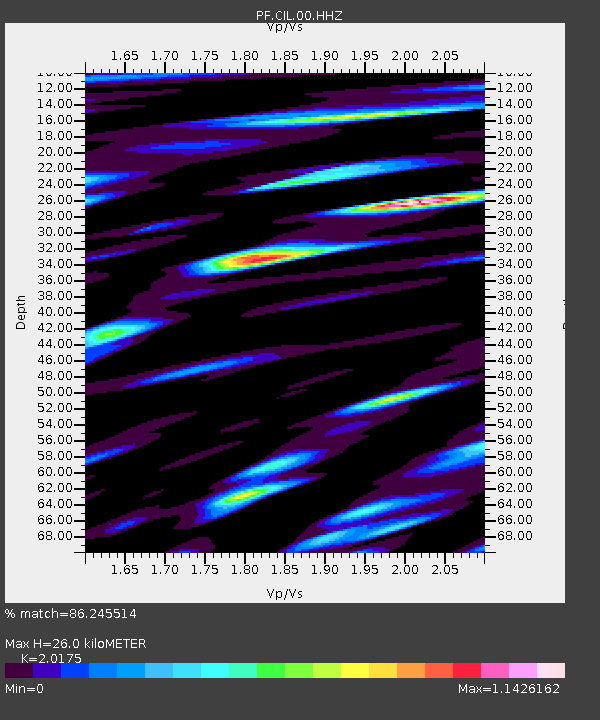
| Estimated Moho Depth: |
26.0 km |
| Estimated Crust Vp/Vs: |
2.02 |
| Assumed Crust Vp: |
4.73 km/s |
| Estimated Crust Vs: |
2.344 km/s |
| Estimated Crust Poisson's Ratio: |
0.34 |
|
| Radial Match: |
86.245514 % |
| Radial Bump: |
400 |
| Transverse Match: |
66.49505 % |
| Transverse Bump: |
400 |
| SOD ConfigId: |
3390531 |
| Insert Time: |
2019-04-12 14:03:19.415 +0000 |
| GWidth: |
2.5 |
| Max Bumps: |
400 |
| Tol: |
0.001 |
|
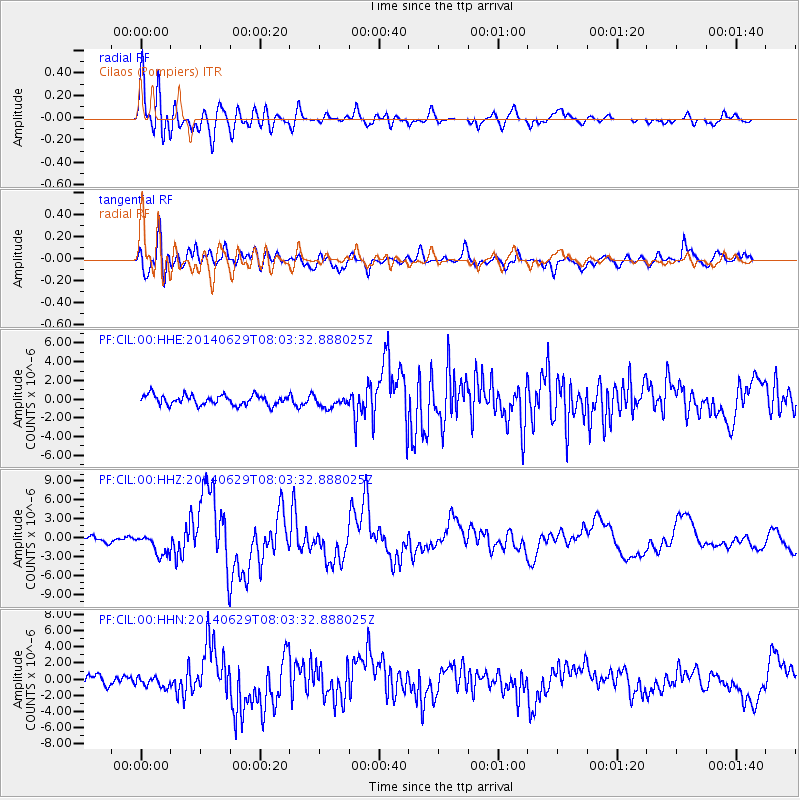
Signal To Noise
| Channel | StoN | STA | LTA |
| PF:CIL:00:HHZ:20140629T08:03:32.888025Z | 3.786971 | 1.6997749E-6 | 4.4884814E-7 |
| PF:CIL:00:HHN:20140629T08:03:32.888025Z | 1.0679544 | 7.0196876E-7 | 6.5730217E-7 |
| PF:CIL:00:HHE:20140629T08:03:32.888025Z | 1.1779019 | 6.146462E-7 | 5.2181446E-7 |
| Arrivals |
| Ps | 5.7 SECOND |
| PpPs | 16 SECOND |
| PsPs/PpSs | 22 SECOND |


