You are here: Home > Network List > AZ - ANZA Regional Network Stations List
> Station SMER AZ.SMER > Earthquake Result Viewer
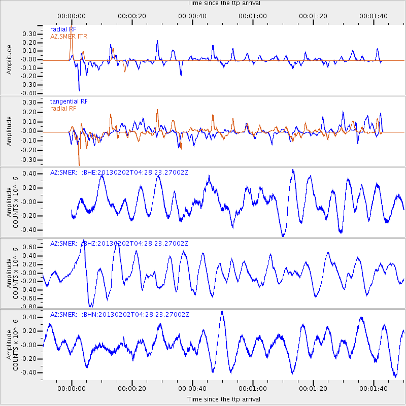
SMER AZ.SMER - Earthquake Result Viewer
*The percent match for this event was below the threshold and hence no stack was calculated.
| Earthquake location: |
Santa Cruz Islands |
| Earthquake latitude/longitude: |
-11.0/165.4 |
| Earthquake time(UTC): |
2013/02/02 (033) 04:16:17 GMT |
| Earthquake Depth: |
22 km |
| Earthquake Magnitude: |
5.6 MS, 5.4 MB, 5.8 MW, 5.9 MW |
| Earthquake Catalog/Contributor: |
WHDF/NEIC |
|
| Network: |
AZ ANZA Regional Network |
| Station: |
SMER AZ.SMER |
| Lat/Lon: |
33.46 N/117.17 W |
| Elevation: |
355 m |
|
| Distance: |
85.7 deg |
| Az: |
54.921 deg |
| Baz: |
254.007 deg |
| Ray Param: |
$rayparam |
*The percent match for this event was below the threshold and hence was not used in the summary stack. |
|
| Radial Match: |
65.57399 % |
| Radial Bump: |
369 |
| Transverse Match: |
50.637405 % |
| Transverse Bump: |
400 |
| SOD ConfigId: |
494114 |
| Insert Time: |
2013-04-27 05:59:50.888 +0000 |
| GWidth: |
2.5 |
| Max Bumps: |
400 |
| Tol: |
0.001 |
|
Signal To Noise
| Channel | StoN | STA | LTA |
| AZ:SMER: :BHZ:20130202T04:28:23.27002Z | 2.798639 | 4.165455E-7 | 1.488386E-7 |
| AZ:SMER: :BHN:20130202T04:28:23.27002Z | 0.9813029 | 1.3059653E-7 | 1.3308484E-7 |
| AZ:SMER: :BHE:20130202T04:28:23.27002Z | 1.1237524 | 1.7267425E-7 | 1.5365863E-7 |
| Arrivals |
| Ps | |
| PpPs | |
| PsPs/PpSs | |


