You are here: Home > Network List > WI - West Indies IPGP Network Stations List
> Station DSLB Salisbury, Dominica > Earthquake Result Viewer
DSLB Salisbury, Dominica - Earthquake Result Viewer
| Earthquake location: |
South Sandwich Islands Region |
| Earthquake latitude/longitude: |
-55.5/-28.5 |
| Earthquake time(UTC): |
2014/06/29 (180) 07:52:56 GMT |
| Earthquake Depth: |
16 km |
| Earthquake Magnitude: |
6.9 MWW, 7.2 MI |
| Earthquake Catalog/Contributor: |
NEIC PDE/NEIC COMCAT |
|
| Network: |
WI West Indies IPGP Network |
| Station: |
DSLB Salisbury, Dominica |
| Lat/Lon: |
15.44 N/61.42 W |
| Elevation: |
324 m |
|
| Distance: |
76.0 deg |
| Az: |
327.248 deg |
| Baz: |
161.389 deg |
| Ray Param: |
0.051308736 |
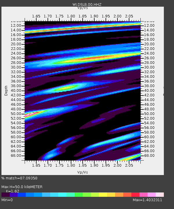
| Estimated Moho Depth: |
50.0 km |
| Estimated Crust Vp/Vs: |
1.62 |
| Assumed Crust Vp: |
5.88 km/s |
| Estimated Crust Vs: |
3.63 km/s |
| Estimated Crust Poisson's Ratio: |
0.19 |
|
| Radial Match: |
87.09358 % |
| Radial Bump: |
400 |
| Transverse Match: |
84.08336 % |
| Transverse Bump: |
400 |
| SOD ConfigId: |
3390531 |
| Insert Time: |
2019-04-12 14:03:49.171 +0000 |
| GWidth: |
2.5 |
| Max Bumps: |
400 |
| Tol: |
0.001 |
|

Signal To Noise
| Channel | StoN | STA | LTA |
| WI:DSLB:00:HHZ:20140629T08:04:11.560022Z | 4.220203 | 2.578867E-6 | 6.1107653E-7 |
| WI:DSLB:00:HHN:20140629T08:04:11.560022Z | 1.3115582 | 1.1800521E-6 | 8.997329E-7 |
| WI:DSLB:00:HHE:20140629T08:04:11.560022Z | 1.308475 | 1.1112285E-6 | 8.492546E-7 |
| Arrivals |
| Ps | 5.4 SECOND |
| PpPs | 22 SECOND |
| PsPs/PpSs | 27 SECOND |


