You are here: Home > Network List > XJ13 - CRAFTI Stations List
> Station LL21 Loliondo SS > Earthquake Result Viewer
LL21 Loliondo SS - Earthquake Result Viewer
| Earthquake location: |
South Sandwich Islands Region |
| Earthquake latitude/longitude: |
-55.5/-28.5 |
| Earthquake time(UTC): |
2014/06/29 (180) 07:52:56 GMT |
| Earthquake Depth: |
16 km |
| Earthquake Magnitude: |
6.9 MWW, 7.2 MI |
| Earthquake Catalog/Contributor: |
NEIC PDE/NEIC COMCAT |
|
| Network: |
XJ CRAFTI |
| Station: |
LL21 Loliondo SS |
| Lat/Lon: |
2.06 S/35.55 E |
| Elevation: |
2040 m |
|
| Distance: |
73.8 deg |
| Az: |
69.271 deg |
| Baz: |
212.169 deg |
| Ray Param: |
0.052734878 |
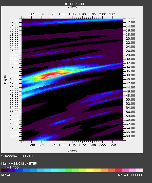
| Estimated Moho Depth: |
38.0 km |
| Estimated Crust Vp/Vs: |
1.75 |
| Assumed Crust Vp: |
6.576 km/s |
| Estimated Crust Vs: |
3.747 km/s |
| Estimated Crust Poisson's Ratio: |
0.26 |
|
| Radial Match: |
98.41748 % |
| Radial Bump: |
299 |
| Transverse Match: |
83.70287 % |
| Transverse Bump: |
400 |
| SOD ConfigId: |
3390531 |
| Insert Time: |
2019-04-12 14:03:53.934 +0000 |
| GWidth: |
2.5 |
| Max Bumps: |
400 |
| Tol: |
0.001 |
|

Signal To Noise
| Channel | StoN | STA | LTA |
| XJ:LL21: :BHZ:20140629T08:03:59.07998Z | 5.3302636 | 6.0052975E-7 | 1.12664175E-7 |
| XJ:LL21: :BHN:20140629T08:03:59.07998Z | 1.7790854 | 2.551393E-7 | 1.4341038E-7 |
| XJ:LL21: :BHE:20140629T08:03:59.07998Z | 0.9493036 | 9.4036075E-8 | 9.905796E-8 |
| Arrivals |
| Ps | 4.5 SECOND |
| PpPs | 15 SECOND |
| PsPs/PpSs | 20 SECOND |


