You are here: Home > Network List > GT - Global Telemetered Seismograph Network (USAF/USGS) Stations List
> Station BDFB Brasilia, Brazil > Earthquake Result Viewer
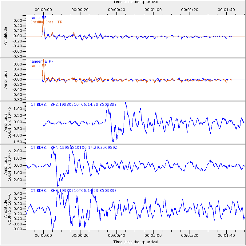
BDFB Brasilia, Brazil - Earthquake Result Viewer

| Earthquake location: |
Near Coast Of Guatemala |
| Earthquake latitude/longitude: |
13.7/-90.7 |
| Earthquake time(UTC): |
1998/05/10 (130) 06:05:58 GMT |
| Earthquake Depth: |
33 km |
| Earthquake Magnitude: |
5.3 MB, 5.9 MS, 6.3 UNKNOWN, 5.3 MD |
| Earthquake Catalog/Contributor: |
WHDF/NEIC |
|
| Network: |
GT Global Telemetered Seismograph Network (USAF/USGS) |
| Station: |
BDFB Brasilia, Brazil |
| Lat/Lon: |
15.64 S/48.01 W |
| Elevation: |
1195 m |
|
| Distance: |
51.3 deg |
| Az: |
123.132 deg |
| Baz: |
302.342 deg |
| Ray Param: |
0.06742595 |
| Estimated Moho Depth: |
42.0 km |
| Estimated Crust Vp/Vs: |
1.69 |
| Assumed Crust Vp: |
6.419 km/s |
| Estimated Crust Vs: |
3.798 km/s |
| Estimated Crust Poisson's Ratio: |
0.23 |
|
| Radial Match: |
94.3493 % |
| Radial Bump: |
377 |
| Transverse Match: |
83.55233 % |
| Transverse Bump: |
400 |
| SOD ConfigId: |
4480 |
| Insert Time: |
2010-02-27 01:37:02.008 +0000 |
| GWidth: |
2.5 |
| Max Bumps: |
400 |
| Tol: |
0.001 |
|
Signal To Noise
| Channel | StoN | STA | LTA |
| GT:BDFB: :BHN:19980510T06:14:29.350989Z | 4.966488 | 6.06819E-7 | 1.2218273E-7 |
| GT:BDFB: :BHE:19980510T06:14:29.350989Z | 2.2774394 | 2.2745722E-7 | 9.98741E-8 |
| GT:BDFB: :BHZ:19980510T06:14:29.350989Z | 3.887783 | 3.3291158E-7 | 8.563018E-8 |
| Arrivals |
| Ps | 4.8 SECOND |
| PpPs | 17 SECOND |
| PsPs/PpSs | 21 SECOND |


