You are here: Home > Network List > CI - Caltech Regional Seismic Network Stations List
> Station MPM Manuel Prospect Mine, California, USA > Earthquake Result Viewer
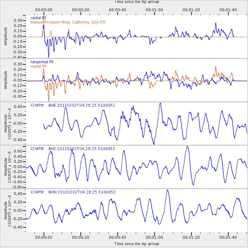
MPM Manuel Prospect Mine, California, USA - Earthquake Result Viewer
*The percent match for this event was below the threshold and hence no stack was calculated.
| Earthquake location: |
Santa Cruz Islands |
| Earthquake latitude/longitude: |
-11.0/165.4 |
| Earthquake time(UTC): |
2013/02/02 (033) 04:16:17 GMT |
| Earthquake Depth: |
22 km |
| Earthquake Magnitude: |
5.6 MS, 5.4 MB, 5.8 MW, 5.9 MW |
| Earthquake Catalog/Contributor: |
WHDF/NEIC |
|
| Network: |
CI Caltech Regional Seismic Network |
| Station: |
MPM Manuel Prospect Mine, California, USA |
| Lat/Lon: |
36.06 N/117.49 W |
| Elevation: |
185 m |
|
| Distance: |
86.2 deg |
| Az: |
52.35 deg |
| Baz: |
253.646 deg |
| Ray Param: |
$rayparam |
*The percent match for this event was below the threshold and hence was not used in the summary stack. |
|
| Radial Match: |
58.250874 % |
| Radial Bump: |
400 |
| Transverse Match: |
46.416214 % |
| Transverse Bump: |
400 |
| SOD ConfigId: |
494114 |
| Insert Time: |
2013-04-27 06:00:43.952 +0000 |
| GWidth: |
2.5 |
| Max Bumps: |
400 |
| Tol: |
0.001 |
|
Signal To Noise
| Channel | StoN | STA | LTA |
| CI:MPM: :BHZ:20130202T04:28:25.619995Z | 3.2478538 | 3.66256E-7 | 1.12768625E-7 |
| CI:MPM: :BHN:20130202T04:28:25.619995Z | 0.4760694 | 7.2455414E-8 | 1.5219507E-7 |
| CI:MPM: :BHE:20130202T04:28:25.619995Z | 1.4370433 | 2.1114903E-7 | 1.4693296E-7 |
| Arrivals |
| Ps | |
| PpPs | |
| PsPs/PpSs | |


