You are here: Home > Network List > XJ13 - CRAFTI Stations List
> Station LL24 Masusu PS > Earthquake Result Viewer
LL24 Masusu PS - Earthquake Result Viewer
| Earthquake location: |
South Sandwich Islands Region |
| Earthquake latitude/longitude: |
-55.5/-28.5 |
| Earthquake time(UTC): |
2014/06/29 (180) 07:52:56 GMT |
| Earthquake Depth: |
16 km |
| Earthquake Magnitude: |
6.9 MWW, 7.2 MI |
| Earthquake Catalog/Contributor: |
NEIC PDE/NEIC COMCAT |
|
| Network: |
XJ CRAFTI |
| Station: |
LL24 Masusu PS |
| Lat/Lon: |
2.27 S/35.81 E |
| Elevation: |
1210 m |
|
| Distance: |
73.8 deg |
| Az: |
69.609 deg |
| Baz: |
212.253 deg |
| Ray Param: |
0.052758105 |
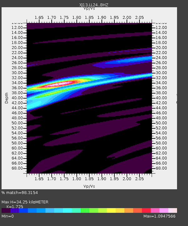
| Estimated Moho Depth: |
34.25 km |
| Estimated Crust Vp/Vs: |
1.73 |
| Assumed Crust Vp: |
6.576 km/s |
| Estimated Crust Vs: |
3.812 km/s |
| Estimated Crust Poisson's Ratio: |
0.25 |
|
| Radial Match: |
98.3154 % |
| Radial Bump: |
226 |
| Transverse Match: |
81.89562 % |
| Transverse Bump: |
400 |
| SOD ConfigId: |
3390531 |
| Insert Time: |
2019-04-12 14:03:53.814 +0000 |
| GWidth: |
2.5 |
| Max Bumps: |
400 |
| Tol: |
0.001 |
|

Signal To Noise
| Channel | StoN | STA | LTA |
| XJ:LL24: :BHZ:20140629T08:03:58.880029Z | 6.3908195 | 6.0196726E-7 | 9.41925E-8 |
| XJ:LL24: :BHN:20140629T08:03:58.880029Z | 1.7938013 | 2.7146535E-7 | 1.5133523E-7 |
| XJ:LL24: :BHE:20140629T08:03:58.880029Z | 1.4944543 | 1.3435451E-7 | 8.990206E-8 |
| Arrivals |
| Ps | 3.9 SECOND |
| PpPs | 14 SECOND |
| PsPs/PpSs | 18 SECOND |


