You are here: Home > Network List > XJ13 - CRAFTI Stations List
> Station LL23 Sali PS > Earthquake Result Viewer
LL23 Sali PS - Earthquake Result Viewer
| Earthquake location: |
South Sandwich Islands Region |
| Earthquake latitude/longitude: |
-55.5/-28.5 |
| Earthquake time(UTC): |
2014/06/29 (180) 07:52:56 GMT |
| Earthquake Depth: |
16 km |
| Earthquake Magnitude: |
6.9 MWW, 7.2 MI |
| Earthquake Catalog/Contributor: |
NEIC PDE/NEIC COMCAT |
|
| Network: |
XJ CRAFTI |
| Station: |
LL23 Sali PS |
| Lat/Lon: |
2.30 S/35.69 E |
| Elevation: |
1257 m |
|
| Distance: |
73.7 deg |
| Az: |
69.523 deg |
| Baz: |
212.234 deg |
| Ray Param: |
0.052817438 |
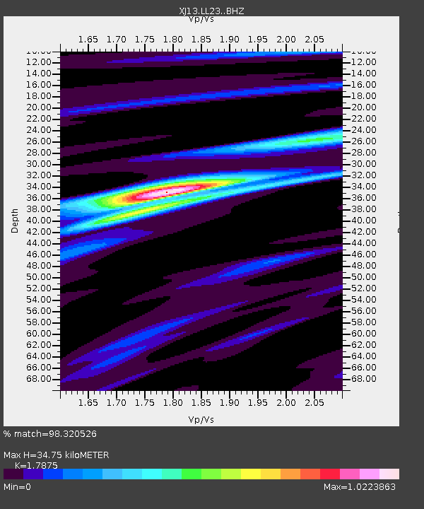
| Estimated Moho Depth: |
34.75 km |
| Estimated Crust Vp/Vs: |
1.79 |
| Assumed Crust Vp: |
6.576 km/s |
| Estimated Crust Vs: |
3.679 km/s |
| Estimated Crust Poisson's Ratio: |
0.27 |
|
| Radial Match: |
98.320526 % |
| Radial Bump: |
260 |
| Transverse Match: |
89.33012 % |
| Transverse Bump: |
400 |
| SOD ConfigId: |
3390531 |
| Insert Time: |
2019-04-12 14:03:54.025 +0000 |
| GWidth: |
2.5 |
| Max Bumps: |
400 |
| Tol: |
0.001 |
|

Signal To Noise
| Channel | StoN | STA | LTA |
| XJ:LL23: :BHZ:20140629T08:03:58.380029Z | 7.8756533 | 6.5148663E-7 | 8.27216E-8 |
| XJ:LL23: :BHN:20140629T08:03:58.380029Z | 1.3419108 | 1.8096766E-7 | 1.3485818E-7 |
| XJ:LL23: :BHE:20140629T08:03:58.380029Z | 2.1830137 | 2.494219E-7 | 1.14255776E-7 |
| Arrivals |
| Ps | 4.3 SECOND |
| PpPs | 14 SECOND |
| PsPs/PpSs | 19 SECOND |


