You are here: Home > Network List > XJ13 - CRAFTI Stations List
> Station LL22 Malambo SS > Earthquake Result Viewer
LL22 Malambo SS - Earthquake Result Viewer
| Earthquake location: |
South Sandwich Islands Region |
| Earthquake latitude/longitude: |
-55.5/-28.5 |
| Earthquake time(UTC): |
2014/06/29 (180) 07:52:56 GMT |
| Earthquake Depth: |
16 km |
| Earthquake Magnitude: |
6.9 MWW, 7.2 MI |
| Earthquake Catalog/Contributor: |
NEIC PDE/NEIC COMCAT |
|
| Network: |
XJ CRAFTI |
| Station: |
LL22 Malambo SS |
| Lat/Lon: |
2.52 S/35.60 E |
| Elevation: |
1222 m |
|
| Distance: |
73.5 deg |
| Az: |
69.565 deg |
| Baz: |
212.25 deg |
| Ray Param: |
0.05297425 |
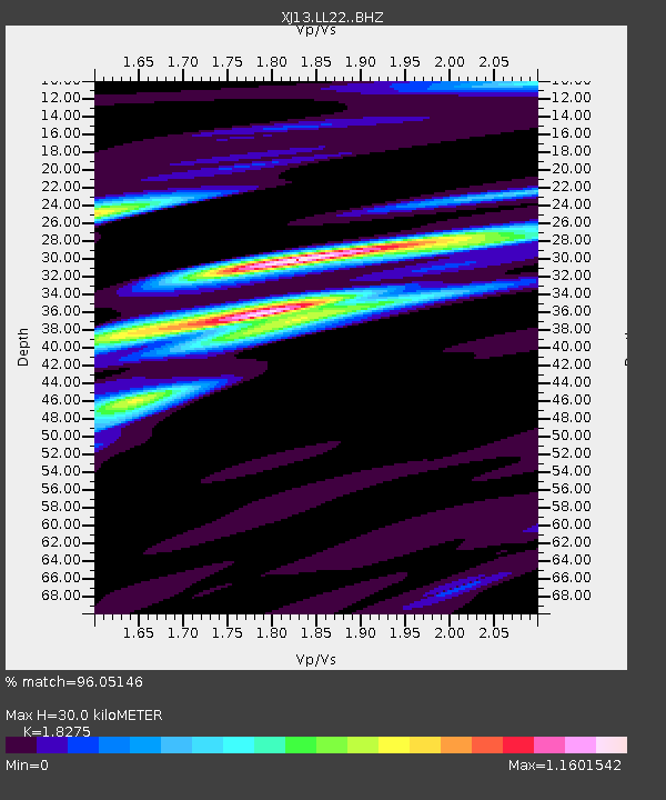
| Estimated Moho Depth: |
30.0 km |
| Estimated Crust Vp/Vs: |
1.83 |
| Assumed Crust Vp: |
6.576 km/s |
| Estimated Crust Vs: |
3.599 km/s |
| Estimated Crust Poisson's Ratio: |
0.29 |
|
| Radial Match: |
96.05146 % |
| Radial Bump: |
400 |
| Transverse Match: |
62.92504 % |
| Transverse Bump: |
400 |
| SOD ConfigId: |
3390531 |
| Insert Time: |
2019-04-12 14:03:54.134 +0000 |
| GWidth: |
2.5 |
| Max Bumps: |
400 |
| Tol: |
0.001 |
|

Signal To Noise
| Channel | StoN | STA | LTA |
| XJ:LL22: :BHZ:20140629T08:03:56.980005Z | 8.194895 | 9.196933E-7 | 1.12227596E-7 |
| XJ:LL22: :BHN:20140629T08:03:56.980005Z | 2.420441 | 3.2063E-7 | 1.3246759E-7 |
| XJ:LL22: :BHE:20140629T08:03:56.980005Z | 2.4682107 | 3.7517046E-7 | 1.5200098E-7 |
| Arrivals |
| Ps | 3.9 SECOND |
| PpPs | 12 SECOND |
| PsPs/PpSs | 16 SECOND |


