You are here: Home > Network List > XJ13 - CRAFTI Stations List
> Station LL65 Arash bomas > Earthquake Result Viewer
LL65 Arash bomas - Earthquake Result Viewer
| Earthquake location: |
South Sandwich Islands Region |
| Earthquake latitude/longitude: |
-55.5/-28.5 |
| Earthquake time(UTC): |
2014/06/29 (180) 07:52:56 GMT |
| Earthquake Depth: |
16 km |
| Earthquake Magnitude: |
6.9 MWW, 7.2 MI |
| Earthquake Catalog/Contributor: |
NEIC PDE/NEIC COMCAT |
|
| Network: |
XJ CRAFTI |
| Station: |
LL65 Arash bomas |
| Lat/Lon: |
2.42 S/35.43 E |
| Elevation: |
1958 m |
|
| Distance: |
73.5 deg |
| Az: |
69.364 deg |
| Baz: |
212.199 deg |
| Ray Param: |
0.052975953 |
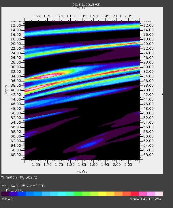
| Estimated Moho Depth: |
38.75 km |
| Estimated Crust Vp/Vs: |
1.65 |
| Assumed Crust Vp: |
6.576 km/s |
| Estimated Crust Vs: |
3.992 km/s |
| Estimated Crust Poisson's Ratio: |
0.21 |
|
| Radial Match: |
98.50272 % |
| Radial Bump: |
275 |
| Transverse Match: |
48.90506 % |
| Transverse Bump: |
400 |
| SOD ConfigId: |
3390531 |
| Insert Time: |
2019-04-12 14:03:56.819 +0000 |
| GWidth: |
2.5 |
| Max Bumps: |
400 |
| Tol: |
0.001 |
|

Signal To Noise
| Channel | StoN | STA | LTA |
| XJ:LL65: :BHZ:20140629T08:03:56.980005Z | 7.8948474 | 7.2391657E-7 | 9.169482E-8 |
| XJ:LL65: :BHN:20140629T08:03:56.980005Z | 3.0350142 | 5.1867244E-7 | 1.708962E-7 |
| XJ:LL65: :BHE:20140629T08:03:56.980005Z | 3.3606093 | 8.0240153E-7 | 2.3876666E-7 |
| Arrivals |
| Ps | 4.0 SECOND |
| PpPs | 15 SECOND |
| PsPs/PpSs | 19 SECOND |


