You are here: Home > Network List > XJ13 - CRAFTI Stations List
> Station LN26 Engaresero PS > Earthquake Result Viewer
LN26 Engaresero PS - Earthquake Result Viewer
| Earthquake location: |
South Sandwich Islands Region |
| Earthquake latitude/longitude: |
-55.5/-28.5 |
| Earthquake time(UTC): |
2014/06/29 (180) 07:52:56 GMT |
| Earthquake Depth: |
16 km |
| Earthquake Magnitude: |
6.9 MWW, 7.2 MI |
| Earthquake Catalog/Contributor: |
NEIC PDE/NEIC COMCAT |
|
| Network: |
XJ CRAFTI |
| Station: |
LN26 Engaresero PS |
| Lat/Lon: |
2.61 S/35.88 E |
| Elevation: |
659 m |
|
| Distance: |
73.5 deg |
| Az: |
69.862 deg |
| Baz: |
212.322 deg |
| Ray Param: |
0.05292576 |
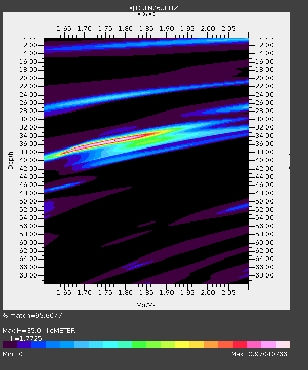
| Estimated Moho Depth: |
35.0 km |
| Estimated Crust Vp/Vs: |
1.77 |
| Assumed Crust Vp: |
6.576 km/s |
| Estimated Crust Vs: |
3.71 km/s |
| Estimated Crust Poisson's Ratio: |
0.27 |
|
| Radial Match: |
95.6077 % |
| Radial Bump: |
400 |
| Transverse Match: |
82.95783 % |
| Transverse Bump: |
400 |
| SOD ConfigId: |
3390531 |
| Insert Time: |
2019-04-12 14:04:01.135 +0000 |
| GWidth: |
2.5 |
| Max Bumps: |
400 |
| Tol: |
0.001 |
|

Signal To Noise
| Channel | StoN | STA | LTA |
| XJ:LN26: :BHZ:20140629T08:03:57.420007Z | 4.4182153 | 7.106925E-7 | 1.6085512E-7 |
| XJ:LN26: :BHN:20140629T08:03:57.420007Z | 1.597507 | 2.6136198E-7 | 1.6360615E-7 |
| XJ:LN26: :BHE:20140629T08:03:57.420007Z | 1.434483 | 2.3434417E-7 | 1.6336489E-7 |
| Arrivals |
| Ps | 4.3 SECOND |
| PpPs | 14 SECOND |
| PsPs/PpSs | 18 SECOND |


