You are here: Home > Network List > XJ13 - CRAFTI Stations List
> Station PR33 Engutoto Boma > Earthquake Result Viewer
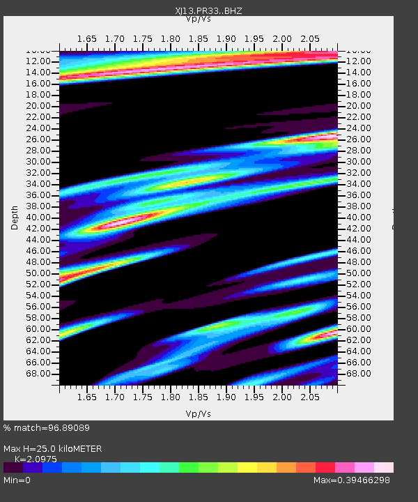
PR33 Engutoto Boma - Earthquake Result Viewer
| Earthquake location: |
South Sandwich Islands Region |
| Earthquake latitude/longitude: |
-55.5/-28.5 |
| Earthquake time(UTC): |
2014/06/29 (180) 07:52:56 GMT |
| Earthquake Depth: |
16 km |
| Earthquake Magnitude: |
6.9 MWW, 7.2 MI |
| Earthquake Catalog/Contributor: |
NEIC PDE/NEIC COMCAT |
|
| Network: |
XJ CRAFTI |
| Station: |
PR33 Engutoto Boma |
| Lat/Lon: |
2.84 S/36.14 E |
| Elevation: |
1101 m |
|
| Distance: |
73.5 deg |
| Az: |
70.219 deg |
| Baz: |
212.41 deg |
| Ray Param: |
0.05296058 |
| Estimated Moho Depth: |
25.0 km |
| Estimated Crust Vp/Vs: |
2.10 |
| Assumed Crust Vp: |
6.601 km/s |
| Estimated Crust Vs: |
3.147 km/s |
| Estimated Crust Poisson's Ratio: |
0.35 |
|
| Radial Match: |
96.89089 % |
| Radial Bump: |
363 |
| Transverse Match: |
82.03056 % |
| Transverse Bump: |
400 |
| SOD ConfigId: |
3390531 |
| Insert Time: |
2019-04-12 14:04:08.789 +0000 |
| GWidth: |
2.5 |
| Max Bumps: |
400 |
| Tol: |
0.001 |
|

Signal To Noise
| Channel | StoN | STA | LTA |
| XJ:PR33: :BHZ:20140629T08:03:57.12002Z | 4.358537 | 5.883415E-7 | 1.34986E-7 |
| XJ:PR33: :BHN:20140629T08:03:57.12002Z | 0.98827577 | 1.6941456E-7 | 1.7142438E-7 |
| XJ:PR33: :BHE:20140629T08:03:57.12002Z | 1.082806 | 2.1126534E-7 | 1.9510914E-7 |
| Arrivals |
| Ps | 4.3 SECOND |
| PpPs | 11 SECOND |
| PsPs/PpSs | 16 SECOND |


