You are here: Home > Network List > XJ13 - CRAFTI Stations List
> Station PR62 Oldupai Boma > Earthquake Result Viewer
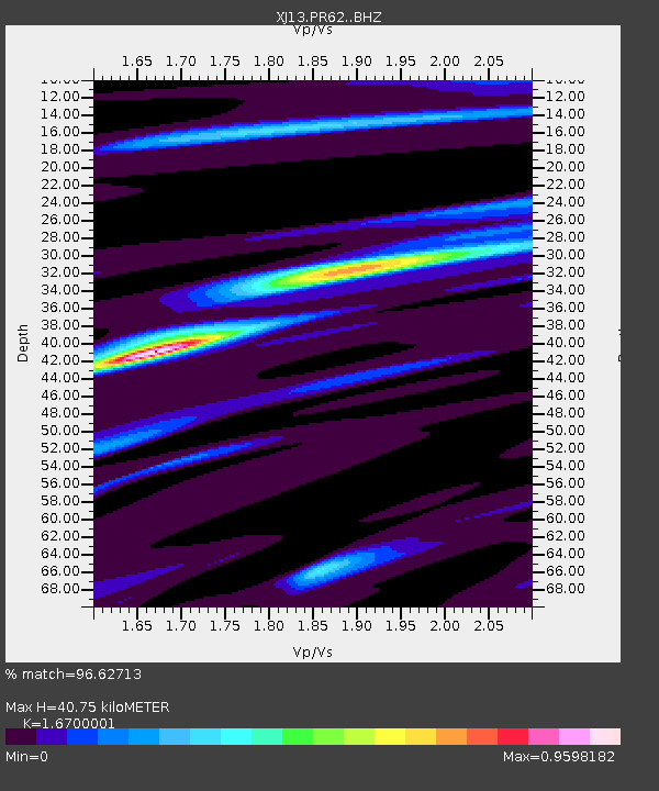
PR62 Oldupai Boma - Earthquake Result Viewer
| Earthquake location: |
South Sandwich Islands Region |
| Earthquake latitude/longitude: |
-55.5/-28.5 |
| Earthquake time(UTC): |
2014/06/29 (180) 07:52:56 GMT |
| Earthquake Depth: |
16 km |
| Earthquake Magnitude: |
6.9 MWW, 7.2 MI |
| Earthquake Catalog/Contributor: |
NEIC PDE/NEIC COMCAT |
|
| Network: |
XJ CRAFTI |
| Station: |
PR62 Oldupai Boma |
| Lat/Lon: |
2.98 S/35.37 E |
| Elevation: |
1454 m |
|
| Distance: |
73.0 deg |
| Az: |
69.624 deg |
| Baz: |
212.277 deg |
| Ray Param: |
0.0533094 |
| Estimated Moho Depth: |
40.75 km |
| Estimated Crust Vp/Vs: |
1.67 |
| Assumed Crust Vp: |
6.576 km/s |
| Estimated Crust Vs: |
3.938 km/s |
| Estimated Crust Poisson's Ratio: |
0.22 |
|
| Radial Match: |
96.62713 % |
| Radial Bump: |
280 |
| Transverse Match: |
77.36254 % |
| Transverse Bump: |
400 |
| SOD ConfigId: |
3390531 |
| Insert Time: |
2019-04-12 14:04:09.186 +0000 |
| GWidth: |
2.5 |
| Max Bumps: |
400 |
| Tol: |
0.001 |
|

Signal To Noise
| Channel | StoN | STA | LTA |
| XJ:PR62: :BHZ:20140629T08:03:53.980005Z | 6.3737707 | 8.6843147E-7 | 1.3625082E-7 |
| XJ:PR62: :BHN:20140629T08:03:53.980005Z | 2.7266426 | 4.6485874E-7 | 1.7048761E-7 |
| XJ:PR62: :BHE:20140629T08:03:53.980005Z | 2.4389145 | 3.3537216E-7 | 1.3750878E-7 |
| Arrivals |
| Ps | 4.3 SECOND |
| PpPs | 16 SECOND |
| PsPs/PpSs | 20 SECOND |


