You are here: Home > Network List > AK - Alaska Regional Network Stations List
> Station WAT4 Susitna Watana 4, AK, USA > Earthquake Result Viewer
WAT4 Susitna Watana 4, AK, USA - Earthquake Result Viewer
| Earthquake location: |
Hokkaido, Japan Region |
| Earthquake latitude/longitude: |
42.8/143.1 |
| Earthquake time(UTC): |
2013/02/02 (033) 14:17:35 GMT |
| Earthquake Depth: |
107 km |
| Earthquake Magnitude: |
6.4 MB, 6.9 MW, 6.9 MW |
| Earthquake Catalog/Contributor: |
WHDF/NEIC |
|
| Network: |
AK Alaska Regional Network |
| Station: |
WAT4 Susitna Watana 4, AK, USA |
| Lat/Lon: |
62.83 N/147.94 W |
| Elevation: |
1191 m |
|
| Distance: |
43.7 deg |
| Az: |
38.285 deg |
| Baz: |
276.288 deg |
| Ray Param: |
0.071982004 |
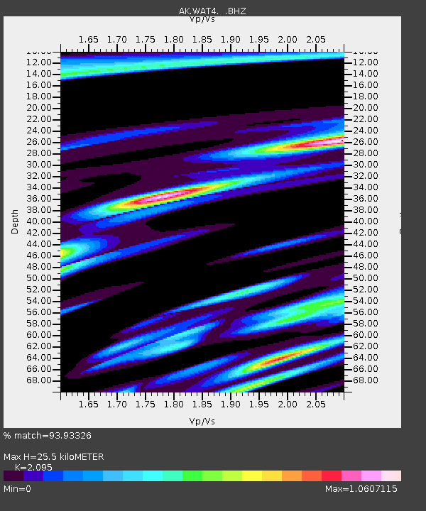
| Estimated Moho Depth: |
25.5 km |
| Estimated Crust Vp/Vs: |
2.10 |
| Assumed Crust Vp: |
6.566 km/s |
| Estimated Crust Vs: |
3.134 km/s |
| Estimated Crust Poisson's Ratio: |
0.35 |
|
| Radial Match: |
93.93326 % |
| Radial Bump: |
400 |
| Transverse Match: |
74.88853 % |
| Transverse Bump: |
400 |
| SOD ConfigId: |
494114 |
| Insert Time: |
2013-04-27 06:05:58.208 +0000 |
| GWidth: |
2.5 |
| Max Bumps: |
400 |
| Tol: |
0.001 |
|

Signal To Noise
| Channel | StoN | STA | LTA |
| AK:WAT4: :BHZ:20130202T14:24:59.428004Z | 28.55424 | 8.405064E-6 | 2.9435435E-7 |
| AK:WAT4: :BHN:20130202T14:24:59.428004Z | 4.061142 | 1.0036797E-6 | 2.4714225E-7 |
| AK:WAT4: :BHE:20130202T14:24:59.428004Z | 24.493607 | 5.2590462E-6 | 2.1471098E-7 |
| Arrivals |
| Ps | 4.5 SECOND |
| PpPs | 11 SECOND |
| PsPs/PpSs | 16 SECOND |


