You are here: Home > Network List > YT07 - POLENET Stations List
> Station LONW LONW > Earthquake Result Viewer
LONW LONW - Earthquake Result Viewer
| Earthquake location: |
South Sandwich Islands Region |
| Earthquake latitude/longitude: |
-55.5/-28.5 |
| Earthquake time(UTC): |
2014/06/29 (180) 07:52:56 GMT |
| Earthquake Depth: |
16 km |
| Earthquake Magnitude: |
6.9 MWW, 7.2 MI |
| Earthquake Catalog/Contributor: |
NEIC PDE/NEIC COMCAT |
|
| Network: |
YT POLENET |
| Station: |
LONW LONW |
| Lat/Lon: |
81.35 S/152.74 E |
| Elevation: |
1548 m |
|
| Distance: |
43.4 deg |
| Az: |
180.261 deg |
| Baz: |
179.018 deg |
| Ray Param: |
0.0725704 |
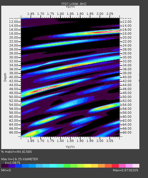
| Estimated Moho Depth: |
16.25 km |
| Estimated Crust Vp/Vs: |
2.10 |
| Assumed Crust Vp: |
6.306 km/s |
| Estimated Crust Vs: |
3.006 km/s |
| Estimated Crust Poisson's Ratio: |
0.35 |
|
| Radial Match: |
94.61565 % |
| Radial Bump: |
400 |
| Transverse Match: |
59.18592 % |
| Transverse Bump: |
400 |
| SOD ConfigId: |
3390531 |
| Insert Time: |
2019-04-12 14:04:35.413 +0000 |
| GWidth: |
2.5 |
| Max Bumps: |
400 |
| Tol: |
0.001 |
|

Signal To Noise
| Channel | StoN | STA | LTA |
| YT:LONW: :BHZ:20140629T08:00:27.925012Z | 13.289564 | 2.1287938E-6 | 1.6018538E-7 |
| YT:LONW: :BHN:20140629T08:00:27.925012Z | 5.2862 | 1.3343283E-6 | 2.524173E-7 |
| YT:LONW: :BHE:20140629T08:00:27.925012Z | 1.1899272 | 1.2240549E-6 | 1.0286806E-6 |
| Arrivals |
| Ps | 3.0 SECOND |
| PpPs | 7.6 SECOND |
| PsPs/PpSs | 11 SECOND |


