You are here: Home > Network List > AU - Australian Seismological Centre Stations List
> Station XMI Christmas Island Airport > Earthquake Result Viewer
XMI Christmas Island Airport - Earthquake Result Viewer
| Earthquake location: |
Hokkaido, Japan Region |
| Earthquake latitude/longitude: |
42.8/143.1 |
| Earthquake time(UTC): |
2013/02/02 (033) 14:17:35 GMT |
| Earthquake Depth: |
107 km |
| Earthquake Magnitude: |
6.4 MB, 6.9 MW, 6.9 MW |
| Earthquake Catalog/Contributor: |
WHDF/NEIC |
|
| Network: |
AU Australian Seismological Centre |
| Station: |
XMI Christmas Island Airport |
| Lat/Lon: |
10.45 S/105.69 E |
| Elevation: |
252 m |
|
| Distance: |
63.0 deg |
| Az: |
222.095 deg |
| Baz: |
30.122 deg |
| Ray Param: |
0.059544418 |
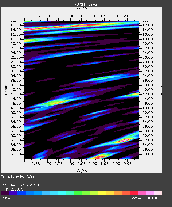
| Estimated Moho Depth: |
61.75 km |
| Estimated Crust Vp/Vs: |
2.04 |
| Assumed Crust Vp: |
4.157 km/s |
| Estimated Crust Vs: |
2.04 km/s |
| Estimated Crust Poisson's Ratio: |
0.34 |
|
| Radial Match: |
90.7188 % |
| Radial Bump: |
400 |
| Transverse Match: |
79.15704 % |
| Transverse Bump: |
400 |
| SOD ConfigId: |
494114 |
| Insert Time: |
2013-04-27 06:08:27.282 +0000 |
| GWidth: |
2.5 |
| Max Bumps: |
400 |
| Tol: |
0.001 |
|

Signal To Noise
| Channel | StoN | STA | LTA |
| AU:XMI: :BHZ:20130202T14:27:20.145015Z | 7.8729897 | 2.879776E-6 | 3.6577924E-7 |
| AU:XMI: :BHN:20130202T14:27:20.145015Z | 3.8547196 | 1.768463E-6 | 4.5877863E-7 |
| AU:XMI: :BHE:20130202T14:27:20.145015Z | 2.3899186 | 1.1674907E-6 | 4.885065E-7 |
| Arrivals |
| Ps | 16 SECOND |
| PpPs | 44 SECOND |
| PsPs/PpSs | 60 SECOND |


