You are here: Home > Network List > AU - Australian Seismological Centre Stations List
> Station MANU Manus Island, Papau New Guinea > Earthquake Result Viewer
MANU Manus Island, Papau New Guinea - Earthquake Result Viewer
| Earthquake location: |
Hokkaido, Japan Region |
| Earthquake latitude/longitude: |
42.8/143.1 |
| Earthquake time(UTC): |
2013/02/02 (033) 14:17:35 GMT |
| Earthquake Depth: |
107 km |
| Earthquake Magnitude: |
6.4 MB, 6.9 MW, 6.9 MW |
| Earthquake Catalog/Contributor: |
WHDF/NEIC |
|
| Network: |
AU Australian Seismological Centre |
| Station: |
MANU Manus Island, Papau New Guinea |
| Lat/Lon: |
2.04 S/147.37 E |
| Elevation: |
142 m |
|
| Distance: |
44.8 deg |
| Az: |
173.93 deg |
| Baz: |
355.531 deg |
| Ray Param: |
0.07133392 |
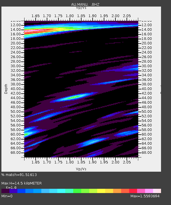
| Estimated Moho Depth: |
14.5 km |
| Estimated Crust Vp/Vs: |
1.60 |
| Assumed Crust Vp: |
4.082 km/s |
| Estimated Crust Vs: |
2.551 km/s |
| Estimated Crust Poisson's Ratio: |
0.18 |
|
| Radial Match: |
91.51613 % |
| Radial Bump: |
395 |
| Transverse Match: |
69.45094 % |
| Transverse Bump: |
400 |
| SOD ConfigId: |
494114 |
| Insert Time: |
2013-04-27 06:09:01.905 +0000 |
| GWidth: |
2.5 |
| Max Bumps: |
400 |
| Tol: |
0.001 |
|

Signal To Noise
| Channel | StoN | STA | LTA |
| AU:MANU: :BHZ:20130202T14:25:07.61999Z | 4.9168496 | 4.0923014E-6 | 8.323015E-7 |
| AU:MANU: :BHN:20130202T14:25:07.61999Z | 4.6700916 | 3.0073288E-6 | 6.43955E-7 |
| AU:MANU: :BHE:20130202T14:25:07.61999Z | 0.9758794 | 5.96996E-7 | 6.117519E-7 |
| Arrivals |
| Ps | 2.2 SECOND |
| PpPs | 9.0 SECOND |
| PsPs/PpSs | 11 SECOND |


