You are here: Home > Network List > AZ - ANZA Regional Network Stations List
> Station SOL AZ.SOL > Earthquake Result Viewer
SOL AZ.SOL - Earthquake Result Viewer

| Earthquake location: |
Hokkaido, Japan Region |
| Earthquake latitude/longitude: |
42.8/143.1 |
| Earthquake time(UTC): |
2013/02/02 (033) 14:17:35 GMT |
| Earthquake Depth: |
107 km |
| Earthquake Magnitude: |
6.4 MB, 6.9 MW, 6.9 MW |
| Earthquake Catalog/Contributor: |
WHDF/NEIC |
|
| Network: |
AZ ANZA Regional Network |
| Station: |
SOL AZ.SOL |
| Lat/Lon: |
32.84 N/117.25 W |
| Elevation: |
245 m |
|
| Distance: |
74.9 deg |
| Az: |
59.287 deg |
| Baz: |
311.235 deg |
| Ray Param: |
0.051800437 |
| Estimated Moho Depth: |
17.0 km |
| Estimated Crust Vp/Vs: |
2.02 |
| Assumed Crust Vp: |
6.264 km/s |
| Estimated Crust Vs: |
3.105 km/s |
| Estimated Crust Poisson's Ratio: |
0.34 |
|
| Radial Match: |
92.03354 % |
| Radial Bump: |
400 |
| Transverse Match: |
87.48679 % |
| Transverse Bump: |
400 |
| SOD ConfigId: |
494114 |
| Insert Time: |
2013-04-27 06:10:02.656 +0000 |
| GWidth: |
2.5 |
| Max Bumps: |
400 |
| Tol: |
0.001 |
|
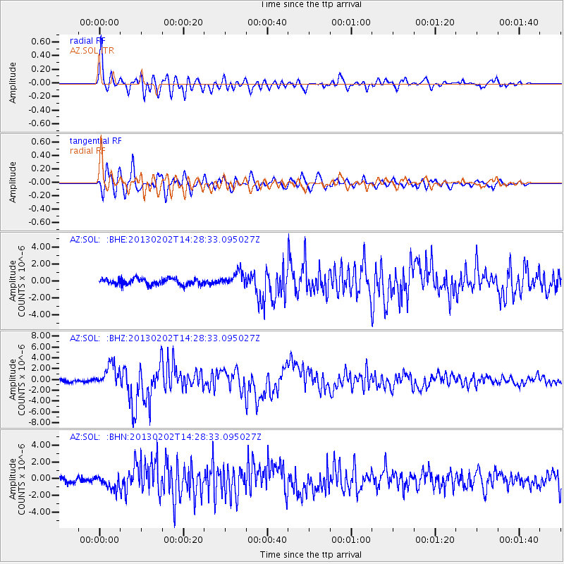
Signal To Noise
| Channel | StoN | STA | LTA |
| AZ:SOL: :BHZ:20130202T14:28:33.095027Z | 9.995132 | 2.1835106E-6 | 2.1845739E-7 |
| AZ:SOL: :BHN:20130202T14:28:33.095027Z | 2.9487987 | 8.354477E-7 | 2.8331797E-7 |
| AZ:SOL: :BHE:20130202T14:28:33.095027Z | 2.4221048 | 8.8367574E-7 | 3.6483794E-7 |
| Arrivals |
| Ps | 2.8 SECOND |
| PpPs | 8.0 SECOND |
| PsPs/PpSs | 11 SECOND |


