You are here: Home > Network List > CH - Switzerland Seismological Network Stations List
> Station SENIN Lac Selin/Sanetsch > Earthquake Result Viewer
SENIN Lac Selin/Sanetsch - Earthquake Result Viewer

| Earthquake location: |
Hokkaido, Japan Region |
| Earthquake latitude/longitude: |
42.8/143.1 |
| Earthquake time(UTC): |
2013/02/02 (033) 14:17:35 GMT |
| Earthquake Depth: |
107 km |
| Earthquake Magnitude: |
6.4 MB, 6.9 MW, 6.9 MW |
| Earthquake Catalog/Contributor: |
WHDF/NEIC |
|
| Network: |
CH Switzerland Seismological Network |
| Station: |
SENIN Lac Selin/Sanetsch |
| Lat/Lon: |
46.36 N/7.30 E |
| Elevation: |
2035 m |
|
| Distance: |
83.0 deg |
| Az: |
330.888 deg |
| Baz: |
31.153 deg |
| Ray Param: |
0.04629132 |
| Estimated Moho Depth: |
17.25 km |
| Estimated Crust Vp/Vs: |
1.66 |
| Assumed Crust Vp: |
6.276 km/s |
| Estimated Crust Vs: |
3.769 km/s |
| Estimated Crust Poisson's Ratio: |
0.22 |
|
| Radial Match: |
85.98358 % |
| Radial Bump: |
400 |
| Transverse Match: |
75.5305 % |
| Transverse Bump: |
400 |
| SOD ConfigId: |
494114 |
| Insert Time: |
2013-04-27 06:11:32.104 +0000 |
| GWidth: |
2.5 |
| Max Bumps: |
400 |
| Tol: |
0.001 |
|
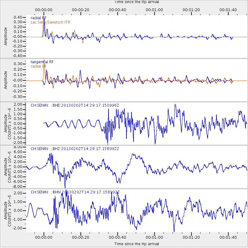
Signal To Noise
| Channel | StoN | STA | LTA |
| CH:SENIN: :BHZ:20130202T14:29:17.158992Z | 7.063474 | 2.7770113E-6 | 3.931509E-7 |
| CH:SENIN: :BHN:20130202T14:29:17.158992Z | 2.2647762 | 8.3023605E-7 | 3.6658633E-7 |
| CH:SENIN: :BHE:20130202T14:29:17.150996Z | 2.8566937 | 7.2961444E-7 | 2.5540518E-7 |
| Arrivals |
| Ps | 1.9 SECOND |
| PpPs | 7.1 SECOND |
| PsPs/PpSs | 9.0 SECOND |


