You are here: Home > Network List > CI - Caltech Regional Seismic Network Stations List
> Station CIA CIA, Avalon Catalina Island, CA, USA > Earthquake Result Viewer
CIA CIA, Avalon Catalina Island, CA, USA - Earthquake Result Viewer
| Earthquake location: |
Hokkaido, Japan Region |
| Earthquake latitude/longitude: |
42.8/143.1 |
| Earthquake time(UTC): |
2013/02/02 (033) 14:17:35 GMT |
| Earthquake Depth: |
107 km |
| Earthquake Magnitude: |
6.4 MB, 6.9 MW, 6.9 MW |
| Earthquake Catalog/Contributor: |
WHDF/NEIC |
|
| Network: |
CI Caltech Regional Seismic Network |
| Station: |
CIA CIA, Avalon Catalina Island, CA, USA |
| Lat/Lon: |
33.40 N/118.41 W |
| Elevation: |
467 m |
|
| Distance: |
73.8 deg |
| Az: |
59.514 deg |
| Baz: |
310.662 deg |
| Ray Param: |
0.052531756 |
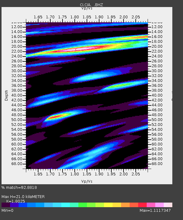
| Estimated Moho Depth: |
21.0 km |
| Estimated Crust Vp/Vs: |
1.80 |
| Assumed Crust Vp: |
6.048 km/s |
| Estimated Crust Vs: |
3.355 km/s |
| Estimated Crust Poisson's Ratio: |
0.28 |
|
| Radial Match: |
92.8818 % |
| Radial Bump: |
400 |
| Transverse Match: |
75.081726 % |
| Transverse Bump: |
400 |
| SOD ConfigId: |
494114 |
| Insert Time: |
2013-04-27 06:13:47.210 +0000 |
| GWidth: |
2.5 |
| Max Bumps: |
400 |
| Tol: |
0.001 |
|
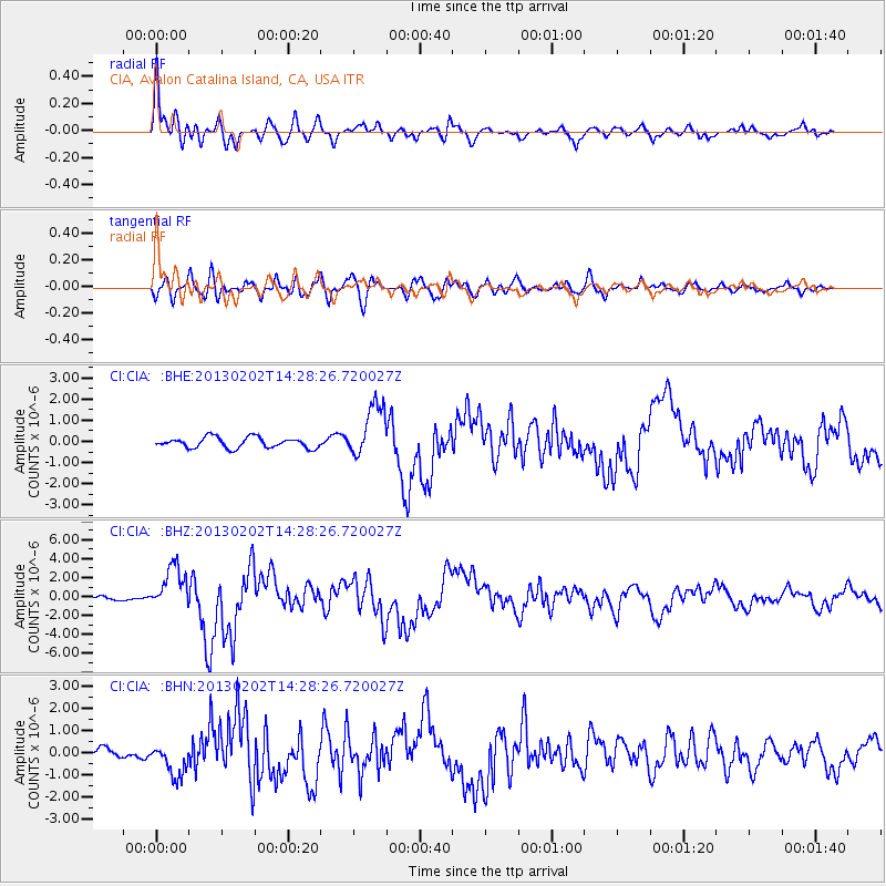
Signal To Noise
| Channel | StoN | STA | LTA |
| CI:CIA: :BHZ:20130202T14:28:26.720027Z | 12.863819 | 2.3038053E-6 | 1.7909186E-7 |
| CI:CIA: :BHN:20130202T14:28:26.720027Z | 3.582797 | 7.3346973E-7 | 2.0471985E-7 |
| CI:CIA: :BHE:20130202T14:28:26.720027Z | 5.050203 | 1.2591769E-6 | 2.4933195E-7 |
| Arrivals |
| Ps | 2.9 SECOND |
| PpPs | 9.5 SECOND |
| PsPs/PpSs | 12 SECOND |


