You are here: Home > Network List > CI - Caltech Regional Seismic Network Stations List
> Station BFS Mt Baldy Forest Station > Earthquake Result Viewer
BFS Mt Baldy Forest Station - Earthquake Result Viewer
| Earthquake location: |
Hokkaido, Japan Region |
| Earthquake latitude/longitude: |
42.8/143.1 |
| Earthquake time(UTC): |
2013/02/02 (033) 14:17:35 GMT |
| Earthquake Depth: |
107 km |
| Earthquake Magnitude: |
6.4 MB, 6.9 MW, 6.9 MW |
| Earthquake Catalog/Contributor: |
WHDF/NEIC |
|
| Network: |
CI Caltech Regional Seismic Network |
| Station: |
BFS Mt Baldy Forest Station |
| Lat/Lon: |
34.24 N/117.66 W |
| Elevation: |
1312 m |
|
| Distance: |
73.7 deg |
| Az: |
58.427 deg |
| Baz: |
310.776 deg |
| Ray Param: |
0.05257726 |
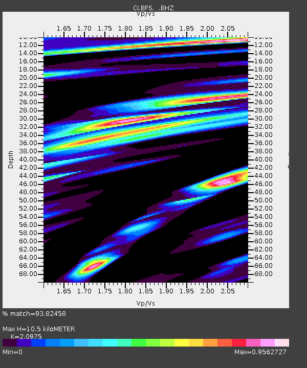
| Estimated Moho Depth: |
10.5 km |
| Estimated Crust Vp/Vs: |
2.10 |
| Assumed Crust Vp: |
6.276 km/s |
| Estimated Crust Vs: |
2.992 km/s |
| Estimated Crust Poisson's Ratio: |
0.35 |
|
| Radial Match: |
93.82458 % |
| Radial Bump: |
400 |
| Transverse Match: |
76.52219 % |
| Transverse Bump: |
400 |
| SOD ConfigId: |
494114 |
| Insert Time: |
2013-04-27 06:15:08.289 +0000 |
| GWidth: |
2.5 |
| Max Bumps: |
400 |
| Tol: |
0.001 |
|
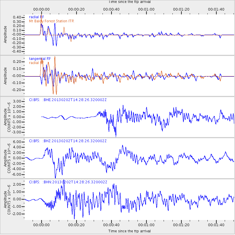
Signal To Noise
| Channel | StoN | STA | LTA |
| CI:BFS: :BHZ:20130202T14:28:26.320002Z | 9.628919 | 2.2461359E-6 | 2.332698E-7 |
| CI:BFS: :BHN:20130202T14:28:26.320002Z | 4.6642604 | 4.8383055E-7 | 1.03731466E-7 |
| CI:BFS: :BHE:20130202T14:28:26.320002Z | 3.5578654 | 5.8110305E-7 | 1.6332913E-7 |
| Arrivals |
| Ps | 1.9 SECOND |
| PpPs | 5.0 SECOND |
| PsPs/PpSs | 6.9 SECOND |


