You are here: Home > Network List > CI - Caltech Regional Seismic Network Stations List
> Station SCZ2 SCZ2, Santa Cruz Is. (E end), CA, USA > Earthquake Result Viewer
SCZ2 SCZ2, Santa Cruz Is. (E end), CA, USA - Earthquake Result Viewer

| Earthquake location: |
Hokkaido, Japan Region |
| Earthquake latitude/longitude: |
42.8/143.1 |
| Earthquake time(UTC): |
2013/02/02 (033) 14:17:35 GMT |
| Earthquake Depth: |
107 km |
| Earthquake Magnitude: |
6.4 MB, 6.9 MW, 6.9 MW |
| Earthquake Catalog/Contributor: |
WHDF/NEIC |
|
| Network: |
CI Caltech Regional Seismic Network |
| Station: |
SCZ2 SCZ2, Santa Cruz Is. (E end), CA, USA |
| Lat/Lon: |
34.00 N/119.64 W |
| Elevation: |
440 m |
|
| Distance: |
72.6 deg |
| Az: |
59.731 deg |
| Baz: |
310.051 deg |
| Ray Param: |
0.053297833 |
| Estimated Moho Depth: |
35.25 km |
| Estimated Crust Vp/Vs: |
1.60 |
| Assumed Crust Vp: |
6.048 km/s |
| Estimated Crust Vs: |
3.774 km/s |
| Estimated Crust Poisson's Ratio: |
0.18 |
|
| Radial Match: |
88.747154 % |
| Radial Bump: |
400 |
| Transverse Match: |
75.14482 % |
| Transverse Bump: |
400 |
| SOD ConfigId: |
494114 |
| Insert Time: |
2013-04-27 06:15:35.203 +0000 |
| GWidth: |
2.5 |
| Max Bumps: |
400 |
| Tol: |
0.001 |
|
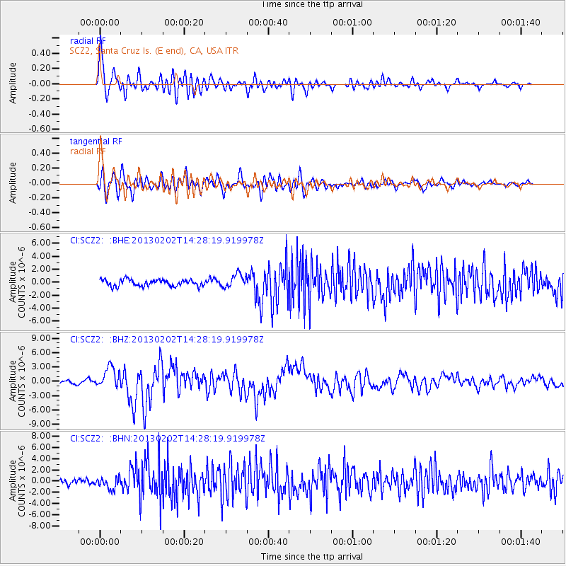
Signal To Noise
| Channel | StoN | STA | LTA |
| CI:SCZ2: :BHZ:20130202T14:28:19.919978Z | 7.19525 | 2.2599236E-6 | 3.140855E-7 |
| CI:SCZ2: :BHN:20130202T14:28:19.919978Z | 2.1017485 | 1.0482258E-6 | 4.987399E-7 |
| CI:SCZ2: :BHE:20130202T14:28:19.919978Z | 2.1554163 | 1.0805397E-6 | 5.0131376E-7 |
| Arrivals |
| Ps | 3.6 SECOND |
| PpPs | 15 SECOND |
| PsPs/PpSs | 18 SECOND |


