You are here: Home > Network List > CN - Canadian National Seismograph Network Stations List
> Station INK INUVIK, NT > Earthquake Result Viewer
INK INUVIK, NT - Earthquake Result Viewer
| Earthquake location: |
Hokkaido, Japan Region |
| Earthquake latitude/longitude: |
42.8/143.1 |
| Earthquake time(UTC): |
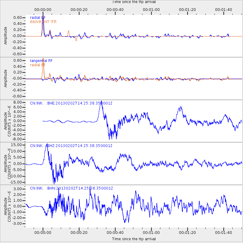
2013/02/02 (033) 14:17:35 GMT |
| Earthquake Depth: |
107 km |
| Earthquake Magnitude: |
6.4 MB, 6.9 MW, 6.9 MW |
| Earthquake Catalog/Contributor: |
WHDF/NEIC |
|
| Network: |
CN Canadian National Seismograph Network |
| Station: |
INK INUVIK, NT |
| Lat/Lon: |
68.31 N/133.53 W |
| Elevation: |
44 m |
|
| Distance: |
48.7 deg |
| Az: |
29.431 deg |
| Baz: |
283.29 deg |
| Ray Param: |
0.068802744 |
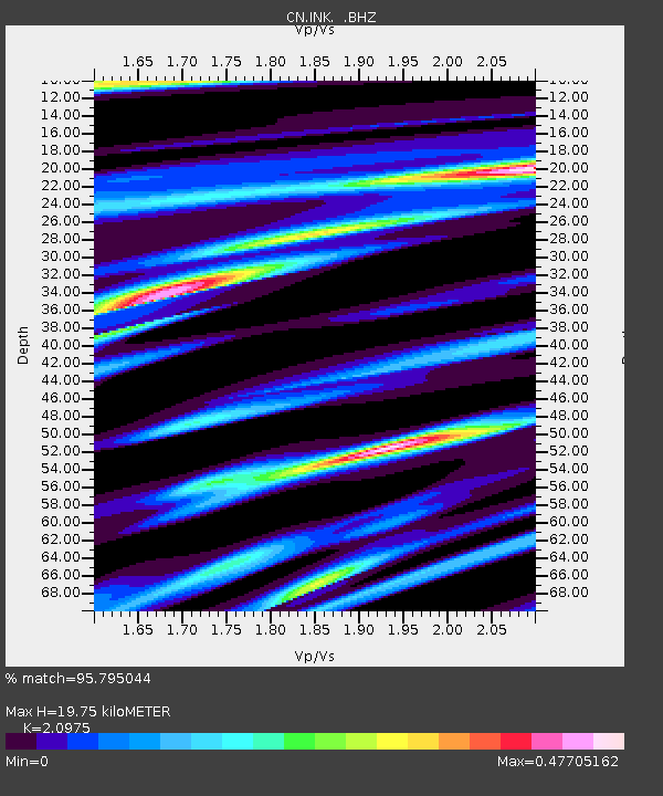
| Estimated Moho Depth: |
19.75 km |
| Estimated Crust Vp/Vs: |
2.10 |
| Assumed Crust Vp: |
6.171 km/s |
| Estimated Crust Vs: |
2.942 km/s |
| Estimated Crust Poisson's Ratio: |
0.35 |
|
| Radial Match: |
95.795044 % |
| Radial Bump: |
345 |
| Transverse Match: |
81.08581 % |
| Transverse Bump: |
400 |
| SOD ConfigId: |
494114 |
| Insert Time: |
2013-04-27 06:16:12.805 +0000 |
| GWidth: |
2.5 |
| Max Bumps: |
400 |
| Tol: |
0.001 |
|
Signal To Noise
| Channel | StoN | STA | LTA |
| CN:INK: :BHZ:20130202T14:25:38.350001Z | 28.871668 | 8.219296E-6 | 2.8468378E-7 |
| CN:INK: :BHN:20130202T14:25:38.350001Z | 2.904307 | 7.3678143E-7 | 2.536858E-7 |
| CN:INK: :BHE:20130202T14:25:38.350001Z | 17.200502 | 4.550118E-6 | 2.6453398E-7 |
| Arrivals |
| Ps | 3.7 SECOND |
| PpPs | 9.5 SECOND |
| PsPs/PpSs | 13 SECOND |


