You are here: Home > Network List > CN - Canadian National Seismograph Network Stations List
> Station SADO SADOWA, ON > Earthquake Result Viewer
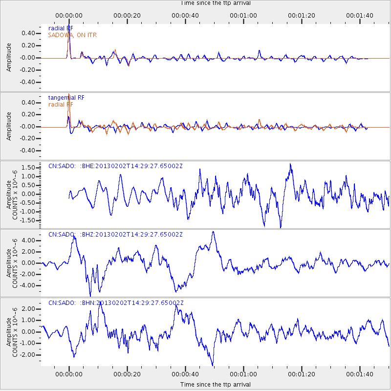
SADO SADOWA, ON - Earthquake Result Viewer

| Earthquake location: |
Hokkaido, Japan Region |
| Earthquake latitude/longitude: |
42.8/143.1 |
| Earthquake time(UTC): |
2013/02/02 (033) 14:17:35 GMT |
| Earthquake Depth: |
107 km |
| Earthquake Magnitude: |
6.4 MB, 6.9 MW, 6.9 MW |
| Earthquake Catalog/Contributor: |
WHDF/NEIC |
|
| Network: |
CN Canadian National Seismograph Network |
| Station: |
SADO SADOWA, ON |
| Lat/Lon: |
44.77 N/79.14 W |
| Elevation: |
243 m |
|
| Distance: |
85.0 deg |
| Az: |
28.724 deg |
| Baz: |
330.211 deg |
| Ray Param: |
0.044821486 |
| Estimated Moho Depth: |
39.5 km |
| Estimated Crust Vp/Vs: |
1.74 |
| Assumed Crust Vp: |
6.577 km/s |
| Estimated Crust Vs: |
3.791 km/s |
| Estimated Crust Poisson's Ratio: |
0.25 |
|
| Radial Match: |
86.1834 % |
| Radial Bump: |
400 |
| Transverse Match: |
54.93261 % |
| Transverse Bump: |
400 |
| SOD ConfigId: |
494114 |
| Insert Time: |
2013-04-27 06:16:37.547 +0000 |
| GWidth: |
2.5 |
| Max Bumps: |
400 |
| Tol: |
0.001 |
|
Signal To Noise
| Channel | StoN | STA | LTA |
| CN:SADO: :BHZ:20130202T14:29:27.65002Z | 8.472628 | 2.6546782E-6 | 3.1332405E-7 |
| CN:SADO: :BHN:20130202T14:29:27.65002Z | 3.1857932 | 1.1364764E-6 | 3.567326E-7 |
| CN:SADO: :BHE:20130202T14:29:27.65002Z | 1.047861 | 4.902462E-7 | 4.678542E-7 |
| Arrivals |
| Ps | 4.5 SECOND |
| PpPs | 16 SECOND |
| PsPs/PpSs | 21 SECOND |


