You are here: Home > Network List > GE - GEOFON Stations List
> Station SUMG GEOFON Station Summit Camp, Greenland > Earthquake Result Viewer
SUMG GEOFON Station Summit Camp, Greenland - Earthquake Result Viewer
| Earthquake location: |
Hokkaido, Japan Region |
| Earthquake latitude/longitude: |
42.8/143.1 |
| Earthquake time(UTC): |
2013/02/02 (033) 14:17:35 GMT |
| Earthquake Depth: |
107 km |
| Earthquake Magnitude: |
6.4 MB, 6.9 MW, 6.9 MW |
| Earthquake Catalog/Contributor: |
WHDF/NEIC |
|
| Network: |
GE GEOFON |
| Station: |
SUMG GEOFON Station Summit Camp, Greenland |
| Lat/Lon: |
72.58 N/38.45 W |
| Elevation: |
3240 m |
|
| Distance: |
65.0 deg |
| Az: |
0.514 deg |
| Baz: |
358.744 deg |
| Ray Param: |
0.058302306 |
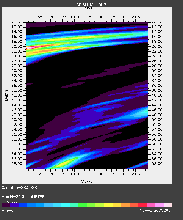
| Estimated Moho Depth: |
20.5 km |
| Estimated Crust Vp/Vs: |
1.60 |
| Assumed Crust Vp: |
6.261 km/s |
| Estimated Crust Vs: |
3.913 km/s |
| Estimated Crust Poisson's Ratio: |
0.18 |
|
| Radial Match: |
88.50387 % |
| Radial Bump: |
400 |
| Transverse Match: |
73.23109 % |
| Transverse Bump: |
400 |
| SOD ConfigId: |
494114 |
| Insert Time: |
2013-04-27 06:18:10.245 +0000 |
| GWidth: |
2.5 |
| Max Bumps: |
400 |
| Tol: |
0.001 |
|

Signal To Noise
| Channel | StoN | STA | LTA |
| GE:SUMG: :BHZ:20130202T14:27:32.645015Z | 7.030557 | 1.7447224E-5 | 2.4816277E-6 |
| GE:SUMG: :BHN:20130202T14:27:32.645015Z | 2.9904149 | 7.558337E-6 | 2.5275212E-6 |
| GE:SUMG: :BHE:20130202T14:27:32.645015Z | 1.3718443 | 2.8547986E-6 | 2.0809932E-6 |
| Arrivals |
| Ps | 2.1 SECOND |
| PpPs | 8.1 SECOND |
| PsPs/PpSs | 10 SECOND |


