You are here: Home > Network List > IW - Intermountain West Stations List
> Station PHWY Pilot Hill, Wyoming, USA > Earthquake Result Viewer
PHWY Pilot Hill, Wyoming, USA - Earthquake Result Viewer
| Earthquake location: |
Hokkaido, Japan Region |
| Earthquake latitude/longitude: |
42.8/143.1 |
| Earthquake time(UTC): |
2013/02/02 (033) 14:17:35 GMT |
| Earthquake Depth: |
107 km |
| Earthquake Magnitude: |
6.4 MB, 6.9 MW, 6.9 MW |
| Earthquake Catalog/Contributor: |
WHDF/NEIC |
|
| Network: |
IW Intermountain West |
| Station: |
PHWY Pilot Hill, Wyoming, USA |
| Lat/Lon: |
41.30 N/105.46 W |
| Elevation: |
2645 m |
|
| Distance: |
76.0 deg |
| Az: |
46.281 deg |
| Baz: |
315.062 deg |
| Ray Param: |
0.05103935 |
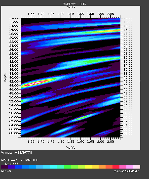
| Estimated Moho Depth: |
42.75 km |
| Estimated Crust Vp/Vs: |
1.66 |
| Assumed Crust Vp: |
6.306 km/s |
| Estimated Crust Vs: |
3.787 km/s |
| Estimated Crust Poisson's Ratio: |
0.22 |
|
| Radial Match: |
88.59778 % |
| Radial Bump: |
400 |
| Transverse Match: |
84.07388 % |
| Transverse Bump: |
400 |
| SOD ConfigId: |
494114 |
| Insert Time: |
2013-04-27 06:19:44.361 +0000 |
| GWidth: |
2.5 |
| Max Bumps: |
400 |
| Tol: |
0.001 |
|

Signal To Noise
| Channel | StoN | STA | LTA |
| IW:PHWY: :BHZ:20130202T14:28:39.590022Z | 5.845087 | 1.9310548E-6 | 3.303723E-7 |
| IW:PHWY: :BHN:20130202T14:28:39.590022Z | 3.1799402 | 6.7164194E-7 | 2.1121213E-7 |
| IW:PHWY: :BHE:20130202T14:28:39.590022Z | 3.0909014 | 5.2682844E-7 | 1.7044492E-7 |
| Arrivals |
| Ps | 4.7 SECOND |
| PpPs | 17 SECOND |
| PsPs/PpSs | 22 SECOND |


