You are here: Home > Network List > TA - USArray Transportable Network (new EarthScope stations) Stations List
> Station O48A Farmland, IN, USA > Earthquake Result Viewer
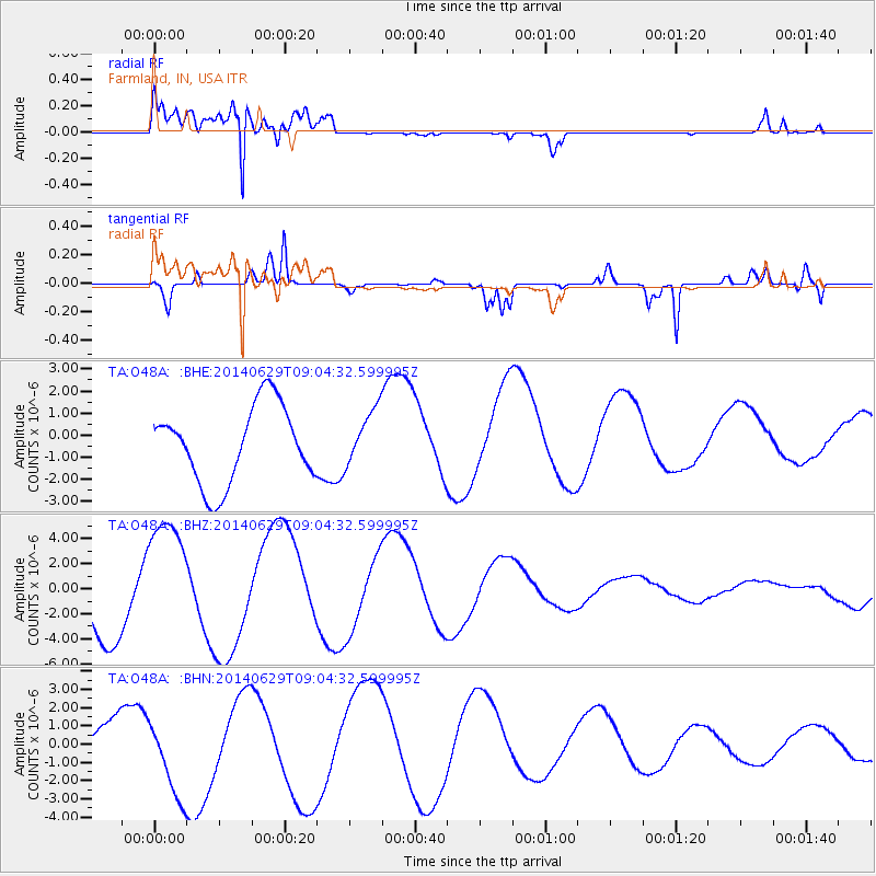
O48A Farmland, IN, USA - Earthquake Result Viewer
*The percent match for this event was below the threshold and hence no stack was calculated.
| Earthquake location: |
Rat Islands, Aleutian Islands |
| Earthquake latitude/longitude: |
51.8/178.5 |
| Earthquake time(UTC): |
2014/06/29 (180) 08:54:45 GMT |
| Earthquake Depth: |
94 km |
| Earthquake Magnitude: |
4.8 mb |
| Earthquake Catalog/Contributor: |
ISC/ISC |
|
| Network: |
TA USArray Transportable Network (new EarthScope stations) |
| Station: |
O48A Farmland, IN, USA |
| Lat/Lon: |
40.26 N/85.16 W |
| Elevation: |
300 m |
|
| Distance: |
63.1 deg |
| Az: |
58.486 deg |
| Baz: |
316.188 deg |
| Ray Param: |
$rayparam |
*The percent match for this event was below the threshold and hence was not used in the summary stack. |
|
| Radial Match: |
95.070595 % |
| Radial Bump: |
400 |
| Transverse Match: |
77.25173 % |
| Transverse Bump: |
400 |
| SOD ConfigId: |
3390531 |
| Insert Time: |
2019-04-12 14:11:47.068 +0000 |
| GWidth: |
2.5 |
| Max Bumps: |
400 |
| Tol: |
0.001 |
|
Signal To Noise
| Channel | StoN | STA | LTA |
| TA:O48A: :BHZ:20140629T09:04:32.599995Z | 1.9582729 | 5.0030185E-6 | 2.5548118E-6 |
| TA:O48A: :BHN:20140629T09:04:32.599995Z | 2.7460988 | 2.87156E-6 | 1.0456871E-6 |
| TA:O48A: :BHE:20140629T09:04:32.599995Z | 0.72438264 | 1.2564824E-6 | 1.7345561E-6 |
| Arrivals |
| Ps | |
| PpPs | |
| PsPs/PpSs | |


