You are here: Home > Network List > US - United States National Seismic Network Stations List
> Station MSO Missoula, Montana, USA > Earthquake Result Viewer
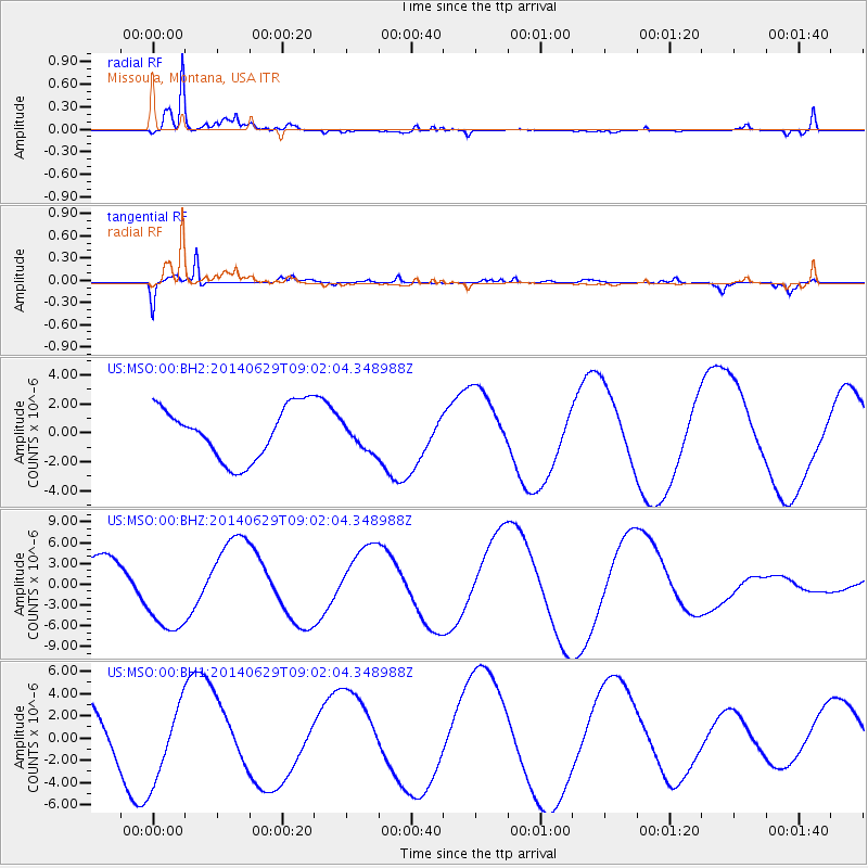
MSO Missoula, Montana, USA - Earthquake Result Viewer
*The percent match for this event was below the threshold and hence no stack was calculated.
| Earthquake location: |
Rat Islands, Aleutian Islands |
| Earthquake latitude/longitude: |
51.8/178.5 |
| Earthquake time(UTC): |
2014/06/29 (180) 08:54:45 GMT |
| Earthquake Depth: |
94 km |
| Earthquake Magnitude: |
4.8 mb |
| Earthquake Catalog/Contributor: |
ISC/ISC |
|
| Network: |
US United States National Seismic Network |
| Station: |
MSO Missoula, Montana, USA |
| Lat/Lon: |
46.83 N/113.94 W |
| Elevation: |
1264 m |
|
| Distance: |
42.9 deg |
| Az: |
68.771 deg |
| Baz: |
302.468 deg |
| Ray Param: |
$rayparam |
*The percent match for this event was below the threshold and hence was not used in the summary stack. |
|
| Radial Match: |
94.65678 % |
| Radial Bump: |
359 |
| Transverse Match: |
76.64794 % |
| Transverse Bump: |
375 |
| SOD ConfigId: |
3390531 |
| Insert Time: |
2019-04-12 14:12:47.759 +0000 |
| GWidth: |
2.5 |
| Max Bumps: |
400 |
| Tol: |
0.001 |
|
Signal To Noise
| Channel | StoN | STA | LTA |
| US:MSO:00:BHZ:20140629T09:02:04.348988Z | 2.7582228 | 6.20347E-6 | 2.2490824E-6 |
| US:MSO:00:BH1:20140629T09:02:04.348988Z | 2.0347054 | 3.4996883E-6 | 1.7199975E-6 |
| US:MSO:00:BH2:20140629T09:02:04.348988Z | 0.5577877 | 1.0113507E-6 | 1.8131461E-6 |
| Arrivals |
| Ps | |
| PpPs | |
| PsPs/PpSs | |


