You are here: Home > Network List > TA - USArray Transportable Network (new EarthScope stations) Stations List
> Station N23A Red Feather Lakes, CO, USA > Earthquake Result Viewer
N23A Red Feather Lakes, CO, USA - Earthquake Result Viewer
| Earthquake location: |
Hokkaido, Japan Region |
| Earthquake latitude/longitude: |
42.8/143.1 |
| Earthquake time(UTC): |
2013/02/02 (033) 14:17:35 GMT |
| Earthquake Depth: |
107 km |
| Earthquake Magnitude: |
6.4 MB, 6.9 MW, 6.9 MW |
| Earthquake Catalog/Contributor: |
WHDF/NEIC |
|
| Network: |
TA USArray Transportable Network (new EarthScope stations) |
| Station: |
N23A Red Feather Lakes, CO, USA |
| Lat/Lon: |
40.89 N/105.94 W |
| Elevation: |
2458 m |
|
| Distance: |
76.0 deg |
| Az: |
46.845 deg |
| Baz: |
314.88 deg |
| Ray Param: |
0.05102112 |
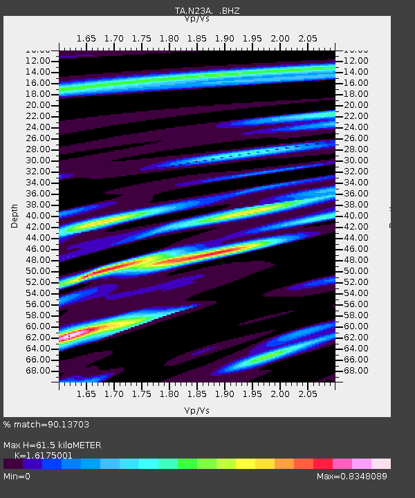
| Estimated Moho Depth: |
61.5 km |
| Estimated Crust Vp/Vs: |
1.62 |
| Assumed Crust Vp: |
6.306 km/s |
| Estimated Crust Vs: |
3.899 km/s |
| Estimated Crust Poisson's Ratio: |
0.19 |
|
| Radial Match: |
90.13703 % |
| Radial Bump: |
400 |
| Transverse Match: |
82.390366 % |
| Transverse Bump: |
400 |
| SOD ConfigId: |
494114 |
| Insert Time: |
2013-04-27 06:27:40.219 +0000 |
| GWidth: |
2.5 |
| Max Bumps: |
400 |
| Tol: |
0.001 |
|
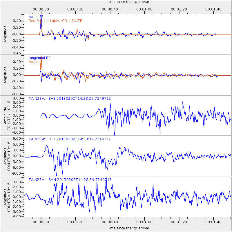
Signal To Noise
| Channel | StoN | STA | LTA |
| TA:N23A: :BHZ:20130202T14:28:39.724971Z | 10.025772 | 3.032336E-6 | 3.024541E-7 |
| TA:N23A: :BHN:20130202T14:28:39.724971Z | 1.9454168 | 7.514619E-7 | 3.8627297E-7 |
| TA:N23A: :BHE:20130202T14:28:39.724971Z | 2.7188253 | 8.6165585E-7 | 3.169221E-7 |
| Arrivals |
| Ps | 6.2 SECOND |
| PpPs | 25 SECOND |
| PsPs/PpSs | 31 SECOND |


