You are here: Home > Network List > TA - USArray Transportable Network (new EarthScope stations) Stations List
> Station I05D Terrebonne, OR, USA > Earthquake Result Viewer
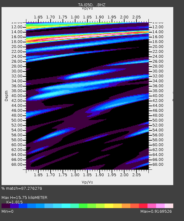
I05D Terrebonne, OR, USA - Earthquake Result Viewer
| Earthquake location: |
Hokkaido, Japan Region |
| Earthquake latitude/longitude: |
42.8/143.1 |
| Earthquake time(UTC): |
2013/02/02 (033) 14:17:35 GMT |
| Earthquake Depth: |
107 km |
| Earthquake Magnitude: |
6.4 MB, 6.9 MW, 6.9 MW |
| Earthquake Catalog/Contributor: |
WHDF/NEIC |
|
| Network: |
TA USArray Transportable Network (new EarthScope stations) |
| Station: |
I05D Terrebonne, OR, USA |
| Lat/Lon: |
44.34 N/121.34 W |
| Elevation: |
1546 m |
|
| Distance: |
65.2 deg |
| Az: |
51.901 deg |
| Baz: |
306.143 deg |
| Ray Param: |
0.058160968 |
| Estimated Moho Depth: |
15.75 km |
| Estimated Crust Vp/Vs: |
1.82 |
| Assumed Crust Vp: |
6.597 km/s |
| Estimated Crust Vs: |
3.635 km/s |
| Estimated Crust Poisson's Ratio: |
0.28 |
|
| Radial Match: |
87.276276 % |
| Radial Bump: |
400 |
| Transverse Match: |
66.42387 % |
| Transverse Bump: |
400 |
| SOD ConfigId: |
494114 |
| Insert Time: |
2013-04-27 06:28:51.564 +0000 |
| GWidth: |
2.5 |
| Max Bumps: |
400 |
| Tol: |
0.001 |
|

Signal To Noise
| Channel | StoN | STA | LTA |
| TA:I05D: :BHZ:20130202T14:27:34.049983Z | 8.667891 | 3.940521E-6 | 4.5461127E-7 |
| TA:I05D: :BHN:20130202T14:27:34.049983Z | 1.6321839 | 1.1754886E-6 | 7.201937E-7 |
| TA:I05D: :BHE:20130202T14:27:34.049983Z | 4.365804 | 1.6005773E-6 | 3.6661683E-7 |
| Arrivals |
| Ps | 2.0 SECOND |
| PpPs | 6.4 SECOND |
| PsPs/PpSs | 8.5 SECOND |


