You are here: Home > Network List > TA - USArray Transportable Network (new EarthScope stations) Stations List
> Station N02D Trinity Center, CA, USA > Earthquake Result Viewer
N02D Trinity Center, CA, USA - Earthquake Result Viewer
| Earthquake location: |
Hokkaido, Japan Region |
| Earthquake latitude/longitude: |
42.8/143.1 |
| Earthquake time(UTC): |
2013/02/02 (033) 14:17:35 GMT |
| Earthquake Depth: |
107 km |
| Earthquake Magnitude: |
6.4 MB, 6.9 MW, 6.9 MW |
| Earthquake Catalog/Contributor: |
WHDF/NEIC |
|
| Network: |
TA USArray Transportable Network (new EarthScope stations) |
| Station: |
N02D Trinity Center, CA, USA |
| Lat/Lon: |
40.97 N/122.71 W |
| Elevation: |
937 m |
|
| Distance: |
66.4 deg |
| Az: |
55.524 deg |
| Baz: |
306.709 deg |
| Ray Param: |
0.057385217 |
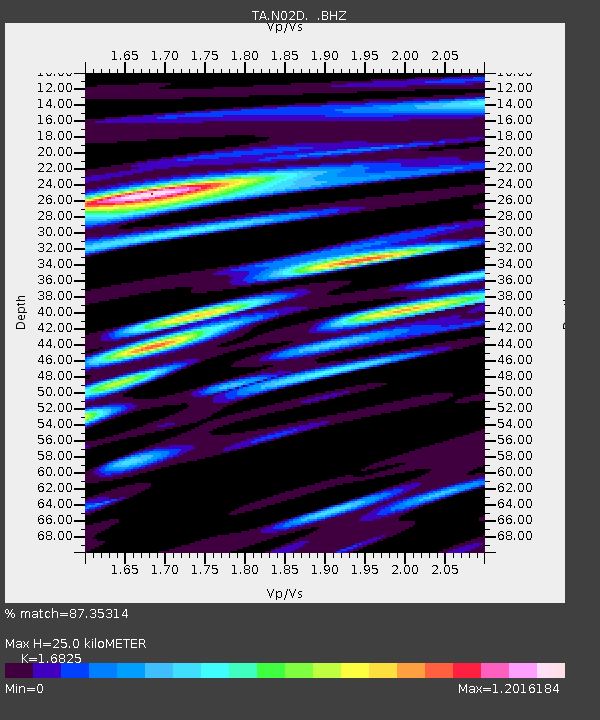
| Estimated Moho Depth: |
25.0 km |
| Estimated Crust Vp/Vs: |
1.68 |
| Assumed Crust Vp: |
6.566 km/s |
| Estimated Crust Vs: |
3.903 km/s |
| Estimated Crust Poisson's Ratio: |
0.23 |
|
| Radial Match: |
87.35314 % |
| Radial Bump: |
400 |
| Transverse Match: |
82.7572 % |
| Transverse Bump: |
400 |
| SOD ConfigId: |
494114 |
| Insert Time: |
2013-04-27 06:29:15.436 +0000 |
| GWidth: |
2.5 |
| Max Bumps: |
400 |
| Tol: |
0.001 |
|
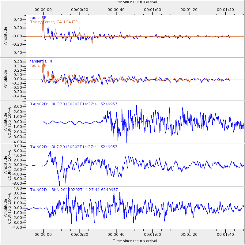
Signal To Noise
| Channel | StoN | STA | LTA |
| TA:N02D: :BHZ:20130202T14:27:41.624995Z | 15.124887 | 2.6840803E-6 | 1.7746117E-7 |
| TA:N02D: :BHN:20130202T14:27:41.624995Z | 5.3677583 | 7.9832165E-7 | 1.4872533E-7 |
| TA:N02D: :BHE:20130202T14:27:41.624995Z | 3.2438524 | 5.749066E-7 | 1.7722958E-7 |
| Arrivals |
| Ps | 2.7 SECOND |
| PpPs | 9.8 SECOND |
| PsPs/PpSs | 12 SECOND |


