You are here: Home > Network List > TA - USArray Transportable Network (new EarthScope stations) Stations List
> Station S43A Fulton Ridge, Patton, MO, USA > Earthquake Result Viewer
S43A Fulton Ridge, Patton, MO, USA - Earthquake Result Viewer
| Earthquake location: |
Hokkaido, Japan Region |
| Earthquake latitude/longitude: |
42.8/143.1 |
| Earthquake time(UTC): |
2013/02/02 (033) 14:17:35 GMT |
| Earthquake Depth: |
107 km |
| Earthquake Magnitude: |
6.4 MB, 6.9 MW, 6.9 MW |
| Earthquake Catalog/Contributor: |
WHDF/NEIC |
|
| Network: |
TA USArray Transportable Network (new EarthScope stations) |
| Station: |
S43A Fulton Ridge, Patton, MO, USA |
| Lat/Lon: |
37.57 N/90.08 W |
| Elevation: |
263 m |
|
| Distance: |
86.6 deg |
| Az: |
39.577 deg |
| Baz: |
323.812 deg |
| Ray Param: |
0.04373692 |
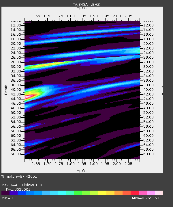
| Estimated Moho Depth: |
43.0 km |
| Estimated Crust Vp/Vs: |
1.60 |
| Assumed Crust Vp: |
6.53 km/s |
| Estimated Crust Vs: |
4.075 km/s |
| Estimated Crust Poisson's Ratio: |
0.18 |
|
| Radial Match: |
87.42051 % |
| Radial Bump: |
400 |
| Transverse Match: |
71.10347 % |
| Transverse Bump: |
400 |
| SOD ConfigId: |
494114 |
| Insert Time: |
2013-04-27 06:34:02.507 +0000 |
| GWidth: |
2.5 |
| Max Bumps: |
400 |
| Tol: |
0.001 |
|

Signal To Noise
| Channel | StoN | STA | LTA |
| TA:S43A: :BHZ:20130202T14:29:35.124995Z | 5.6728835 | 2.8007441E-6 | 4.937073E-7 |
| TA:S43A: :BHN:20130202T14:29:35.124995Z | 1.4921815 | 8.0930346E-7 | 5.423626E-7 |
| TA:S43A: :BHE:20130202T14:29:35.124995Z | 2.4890602 | 7.1621116E-7 | 2.8774363E-7 |
| Arrivals |
| Ps | 4.1 SECOND |
| PpPs | 17 SECOND |
| PsPs/PpSs | 21 SECOND |


