You are here: Home > Network List > TA - USArray Transportable Network (new EarthScope stations) Stations List
> Station K40A Colesburg, IA, USA > Earthquake Result Viewer
K40A Colesburg, IA, USA - Earthquake Result Viewer
| Earthquake location: |
Hokkaido, Japan Region |
| Earthquake latitude/longitude: |
42.8/143.1 |
| Earthquake time(UTC): |
2013/02/02 (033) 14:17:35 GMT |
| Earthquake Depth: |
107 km |
| Earthquake Magnitude: |
6.4 MB, 6.9 MW, 6.9 MW |
| Earthquake Catalog/Contributor: |
WHDF/NEIC |
|
| Network: |
TA USArray Transportable Network (new EarthScope stations) |
| Station: |
K40A Colesburg, IA, USA |
| Lat/Lon: |
42.70 N/91.14 W |
| Elevation: |
274 m |
|
| Distance: |
82.0 deg |
| Az: |
37.162 deg |
| Baz: |
322.887 deg |
| Ray Param: |
0.046983264 |
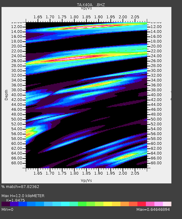
| Estimated Moho Depth: |
12.0 km |
| Estimated Crust Vp/Vs: |
1.85 |
| Assumed Crust Vp: |
6.53 km/s |
| Estimated Crust Vs: |
3.535 km/s |
| Estimated Crust Poisson's Ratio: |
0.29 |
|
| Radial Match: |
87.82362 % |
| Radial Bump: |
400 |
| Transverse Match: |
64.55515 % |
| Transverse Bump: |
400 |
| SOD ConfigId: |
494114 |
| Insert Time: |
2013-04-27 06:34:30.112 +0000 |
| GWidth: |
2.5 |
| Max Bumps: |
400 |
| Tol: |
0.001 |
|

Signal To Noise
| Channel | StoN | STA | LTA |
| TA:K40A: :BHZ:20130202T14:29:11.999995Z | 6.809909 | 3.1449736E-6 | 4.6182313E-7 |
| TA:K40A: :BHN:20130202T14:29:11.999995Z | 2.6691136 | 8.798158E-7 | 3.2962842E-7 |
| TA:K40A: :BHE:20130202T14:29:11.999995Z | 1.6400408 | 5.632679E-7 | 3.4344754E-7 |
| Arrivals |
| Ps | 1.6 SECOND |
| PpPs | 5.1 SECOND |
| PsPs/PpSs | 6.7 SECOND |


