You are here: Home > Network List > TA - USArray Transportable Network (new EarthScope stations) Stations List
> Station J39A Decorah, IA, USA > Earthquake Result Viewer
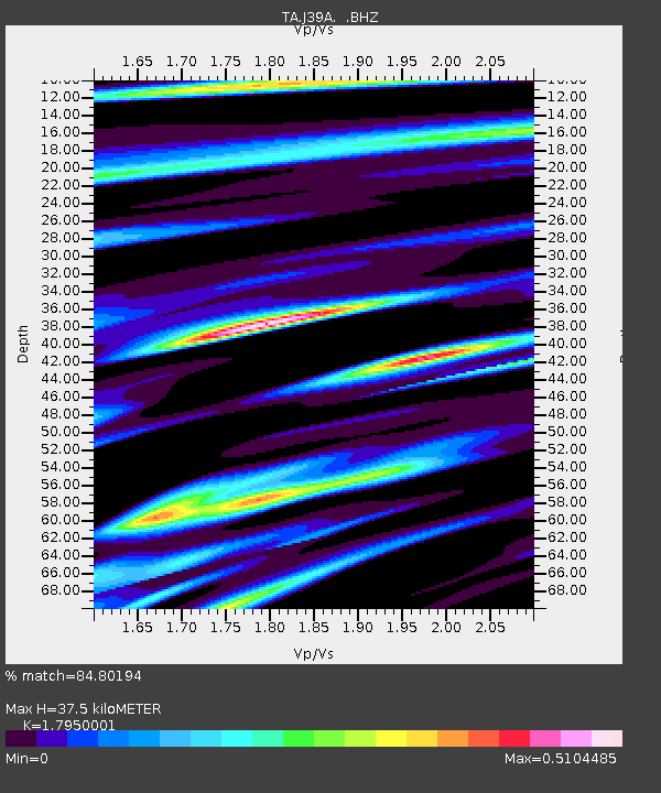
J39A Decorah, IA, USA - Earthquake Result Viewer
| Earthquake location: |
Hokkaido, Japan Region |
| Earthquake latitude/longitude: |
42.8/143.1 |
| Earthquake time(UTC): |
2013/02/02 (033) 14:17:35 GMT |
| Earthquake Depth: |
107 km |
| Earthquake Magnitude: |
6.4 MB, 6.9 MW, 6.9 MW |
| Earthquake Catalog/Contributor: |
WHDF/NEIC |
|
| Network: |
TA USArray Transportable Network (new EarthScope stations) |
| Station: |
J39A Decorah, IA, USA |
| Lat/Lon: |
43.34 N/91.71 W |
| Elevation: |
350 m |
|
| Distance: |
81.2 deg |
| Az: |
37.107 deg |
| Baz: |
322.493 deg |
| Ray Param: |
0.047510542 |
| Estimated Moho Depth: |
37.5 km |
| Estimated Crust Vp/Vs: |
1.80 |
| Assumed Crust Vp: |
6.53 km/s |
| Estimated Crust Vs: |
3.638 km/s |
| Estimated Crust Poisson's Ratio: |
0.27 |
|
| Radial Match: |
84.80194 % |
| Radial Bump: |
400 |
| Transverse Match: |
72.72824 % |
| Transverse Bump: |
400 |
| SOD ConfigId: |
494114 |
| Insert Time: |
2013-04-27 06:34:49.348 +0000 |
| GWidth: |
2.5 |
| Max Bumps: |
400 |
| Tol: |
0.001 |
|

Signal To Noise
| Channel | StoN | STA | LTA |
| TA:J39A: :BHZ:20130202T14:29:08.02502Z | 7.8660007 | 3.2398445E-6 | 4.1187954E-7 |
| TA:J39A: :BHN:20130202T14:29:08.02502Z | 3.4276304 | 1.0592587E-6 | 3.0903527E-7 |
| TA:J39A: :BHE:20130202T14:29:08.02502Z | 3.5485816 | 8.7534505E-7 | 2.4667463E-7 |
| Arrivals |
| Ps | 4.7 SECOND |
| PpPs | 16 SECOND |
| PsPs/PpSs | 20 SECOND |


