You are here: Home > Network List > TA - USArray Transportable Network (new EarthScope stations) Stations List
> Station O42A Bath, IL, USA > Earthquake Result Viewer
O42A Bath, IL, USA - Earthquake Result Viewer
| Earthquake location: |
Hokkaido, Japan Region |
| Earthquake latitude/longitude: |
42.8/143.1 |
| Earthquake time(UTC): |
2013/02/02 (033) 14:17:35 GMT |
| Earthquake Depth: |
107 km |
| Earthquake Magnitude: |
6.4 MB, 6.9 MW, 6.9 MW |
| Earthquake Catalog/Contributor: |
WHDF/NEIC |
|
| Network: |
TA USArray Transportable Network (new EarthScope stations) |
| Station: |
O42A Bath, IL, USA |
| Lat/Lon: |
40.20 N/90.08 W |
| Elevation: |
155 m |
|
| Distance: |
84.4 deg |
| Az: |
38.026 deg |
| Baz: |
323.687 deg |
| Ray Param: |
0.045247342 |
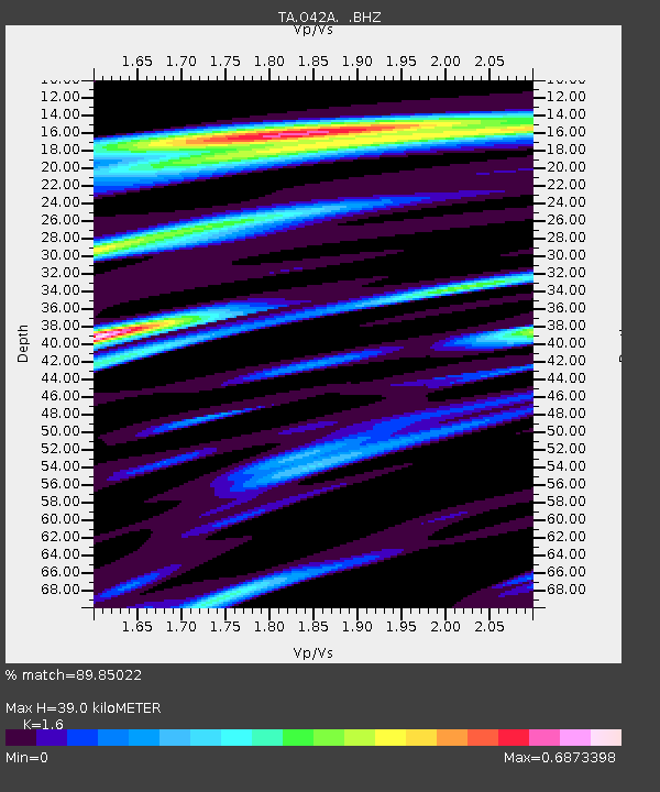
| Estimated Moho Depth: |
39.0 km |
| Estimated Crust Vp/Vs: |
1.60 |
| Assumed Crust Vp: |
6.498 km/s |
| Estimated Crust Vs: |
4.061 km/s |
| Estimated Crust Poisson's Ratio: |
0.18 |
|
| Radial Match: |
89.85022 % |
| Radial Bump: |
400 |
| Transverse Match: |
73.61722 % |
| Transverse Bump: |
400 |
| SOD ConfigId: |
494114 |
| Insert Time: |
2013-04-27 06:34:53.811 +0000 |
| GWidth: |
2.5 |
| Max Bumps: |
400 |
| Tol: |
0.001 |
|

Signal To Noise
| Channel | StoN | STA | LTA |
| TA:O42A: :BHZ:20130202T14:29:24.674983Z | 9.374315 | 3.1408297E-6 | 3.350463E-7 |
| TA:O42A: :BHN:20130202T14:29:24.674983Z | 2.1970975 | 9.469948E-7 | 4.3102082E-7 |
| TA:O42A: :BHE:20130202T14:29:24.674983Z | 2.4820242 | 8.8347855E-7 | 3.559508E-7 |
| Arrivals |
| Ps | 3.7 SECOND |
| PpPs | 15 SECOND |
| PsPs/PpSs | 19 SECOND |


