You are here: Home > Network List > TA - USArray Transportable Network (new EarthScope stations) Stations List
> Station X42A Stuttgart, AR, USA > Earthquake Result Viewer
X42A Stuttgart, AR, USA - Earthquake Result Viewer
| Earthquake location: |
Hokkaido, Japan Region |
| Earthquake latitude/longitude: |
42.8/143.1 |
| Earthquake time(UTC): |
2013/02/02 (033) 14:17:35 GMT |
| Earthquake Depth: |
107 km |
| Earthquake Magnitude: |
6.4 MB, 6.9 MW, 6.9 MW |
| Earthquake Catalog/Contributor: |
WHDF/NEIC |
|
| Network: |
TA USArray Transportable Network (new EarthScope stations) |
| Station: |
X42A Stuttgart, AR, USA |
| Lat/Lon: |
34.55 N/91.63 W |
| Elevation: |
62 m |
|
| Distance: |
88.2 deg |
| Az: |
42.384 deg |
| Baz: |
323.031 deg |
| Ray Param: |
0.042518344 |
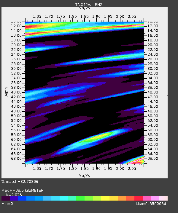
| Estimated Moho Depth: |
68.5 km |
| Estimated Crust Vp/Vs: |
2.08 |
| Assumed Crust Vp: |
6.273 km/s |
| Estimated Crust Vs: |
3.023 km/s |
| Estimated Crust Poisson's Ratio: |
0.35 |
|
| Radial Match: |
82.70866 % |
| Radial Bump: |
400 |
| Transverse Match: |
66.03131 % |
| Transverse Bump: |
400 |
| SOD ConfigId: |
494114 |
| Insert Time: |
2013-04-27 06:36:16.857 +0000 |
| GWidth: |
2.5 |
| Max Bumps: |
400 |
| Tol: |
0.001 |
|
Signal To Noise
| Channel | StoN | STA | LTA |
| TA:X42A: :BHZ:20130202T14:29:43.099971Z | 6.5364704 | 2.0434868E-6 | 3.126285E-7 |
| TA:X42A: :BHN:20130202T14:29:43.099971Z | 1.6272151 | 9.975266E-7 | 6.130268E-7 |
| TA:X42A: :BHE:20130202T14:29:43.099971Z | 0.96304876 | 7.7880077E-7 | 8.0868256E-7 |
| Arrivals |
| Ps | 12 SECOND |
| PpPs | 33 SECOND |
| PsPs/PpSs | 45 SECOND |


