You are here: Home > Network List > TA - USArray Transportable Network (new EarthScope stations) Stations List
> Station R43A Red Bud, IL, USA > Earthquake Result Viewer
R43A Red Bud, IL, USA - Earthquake Result Viewer

| Earthquake location: |
Hokkaido, Japan Region |
| Earthquake latitude/longitude: |
42.8/143.1 |
| Earthquake time(UTC): |
2013/02/02 (033) 14:17:35 GMT |
| Earthquake Depth: |
107 km |
| Earthquake Magnitude: |
6.4 MB, 6.9 MW, 6.9 MW |
| Earthquake Catalog/Contributor: |
WHDF/NEIC |
|
| Network: |
TA USArray Transportable Network (new EarthScope stations) |
| Station: |
R43A Red Bud, IL, USA |
| Lat/Lon: |
38.28 N/89.93 W |
| Elevation: |
186 m |
|
| Distance: |
86.1 deg |
| Az: |
39.069 deg |
| Baz: |
323.868 deg |
| Ray Param: |
0.044098742 |
| Estimated Moho Depth: |
23.0 km |
| Estimated Crust Vp/Vs: |
1.91 |
| Assumed Crust Vp: |
6.444 km/s |
| Estimated Crust Vs: |
3.374 km/s |
| Estimated Crust Poisson's Ratio: |
0.31 |
|
| Radial Match: |
85.06822 % |
| Radial Bump: |
400 |
| Transverse Match: |
66.169174 % |
| Transverse Bump: |
400 |
| SOD ConfigId: |
494114 |
| Insert Time: |
2013-04-27 06:36:44.952 +0000 |
| GWidth: |
2.5 |
| Max Bumps: |
400 |
| Tol: |
0.001 |
|
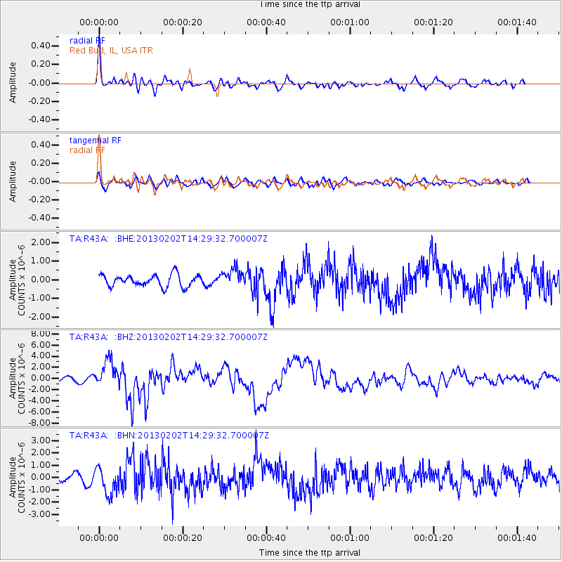
Signal To Noise
| Channel | StoN | STA | LTA |
| TA:R43A: :BHZ:20130202T14:29:32.700007Z | 7.012173 | 2.4718145E-6 | 3.5250332E-7 |
| TA:R43A: :BHN:20130202T14:29:32.700007Z | 2.9932952 | 1.1042243E-6 | 3.6889924E-7 |
| TA:R43A: :BHE:20130202T14:29:32.700007Z | 1.5648538 | 4.910595E-7 | 3.1380534E-7 |
| Arrivals |
| Ps | 3.3 SECOND |
| PpPs | 10 SECOND |
| PsPs/PpSs | 13 SECOND |


