You are here: Home > Network List > TA - USArray Transportable Network (new EarthScope stations) Stations List
> Station I40A Norwalk, WI, USA > Earthquake Result Viewer
I40A Norwalk, WI, USA - Earthquake Result Viewer
| Earthquake location: |
Hokkaido, Japan Region |
| Earthquake latitude/longitude: |
42.8/143.1 |
| Earthquake time(UTC): |
2013/02/02 (033) 14:17:35 GMT |
| Earthquake Depth: |
107 km |
| Earthquake Magnitude: |
6.4 MB, 6.9 MW, 6.9 MW |
| Earthquake Catalog/Contributor: |
WHDF/NEIC |
|
| Network: |
TA USArray Transportable Network (new EarthScope stations) |
| Station: |
I40A Norwalk, WI, USA |
| Lat/Lon: |
43.89 N/90.62 W |
| Elevation: |
419 m |
|
| Distance: |
81.2 deg |
| Az: |
36.13 deg |
| Baz: |
323.092 deg |
| Ray Param: |
0.04748591 |
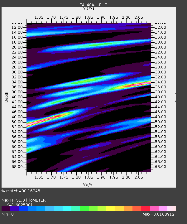
| Estimated Moho Depth: |
51.0 km |
| Estimated Crust Vp/Vs: |
1.60 |
| Assumed Crust Vp: |
6.53 km/s |
| Estimated Crust Vs: |
4.075 km/s |
| Estimated Crust Poisson's Ratio: |
0.18 |
|
| Radial Match: |
88.16245 % |
| Radial Bump: |
400 |
| Transverse Match: |
61.93977 % |
| Transverse Bump: |
400 |
| SOD ConfigId: |
494114 |
| Insert Time: |
2013-04-27 06:36:53.136 +0000 |
| GWidth: |
2.5 |
| Max Bumps: |
400 |
| Tol: |
0.001 |
|

Signal To Noise
| Channel | StoN | STA | LTA |
| TA:I40A: :BHZ:20130202T14:29:08.200007Z | 5.9815307 | 3.0331462E-6 | 5.0708525E-7 |
| TA:I40A: :BHN:20130202T14:29:08.200007Z | 2.0896223 | 8.5872557E-7 | 4.1094776E-7 |
| TA:I40A: :BHE:20130202T14:29:08.200007Z | 2.9673893 | 8.373926E-7 | 2.8219844E-7 |
| Arrivals |
| Ps | 4.9 SECOND |
| PpPs | 20 SECOND |
| PsPs/PpSs | 25 SECOND |


