You are here: Home > Network List > TA - USArray Transportable Network (new EarthScope stations) Stations List
> Station H39A Augusta, WI, USA > Earthquake Result Viewer
H39A Augusta, WI, USA - Earthquake Result Viewer
| Earthquake location: |
Hokkaido, Japan Region |
| Earthquake latitude/longitude: |
42.8/143.1 |
| Earthquake time(UTC): |
2013/02/02 (033) 14:17:35 GMT |
| Earthquake Depth: |
107 km |
| Earthquake Magnitude: |
6.4 MB, 6.9 MW, 6.9 MW |
| Earthquake Catalog/Contributor: |
WHDF/NEIC |
|
| Network: |
TA USArray Transportable Network (new EarthScope stations) |
| Station: |
H39A Augusta, WI, USA |
| Lat/Lon: |
44.68 N/91.28 W |
| Elevation: |
345 m |
|
| Distance: |
80.3 deg |
| Az: |
36.034 deg |
| Baz: |
322.613 deg |
| Ray Param: |
0.04811889 |
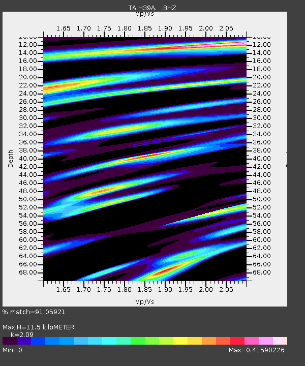
| Estimated Moho Depth: |
11.5 km |
| Estimated Crust Vp/Vs: |
2.09 |
| Assumed Crust Vp: |
6.571 km/s |
| Estimated Crust Vs: |
3.144 km/s |
| Estimated Crust Poisson's Ratio: |
0.35 |
|
| Radial Match: |
91.05921 % |
| Radial Bump: |
400 |
| Transverse Match: |
66.573814 % |
| Transverse Bump: |
400 |
| SOD ConfigId: |
494114 |
| Insert Time: |
2013-04-27 06:37:20.755 +0000 |
| GWidth: |
2.5 |
| Max Bumps: |
400 |
| Tol: |
0.001 |
|
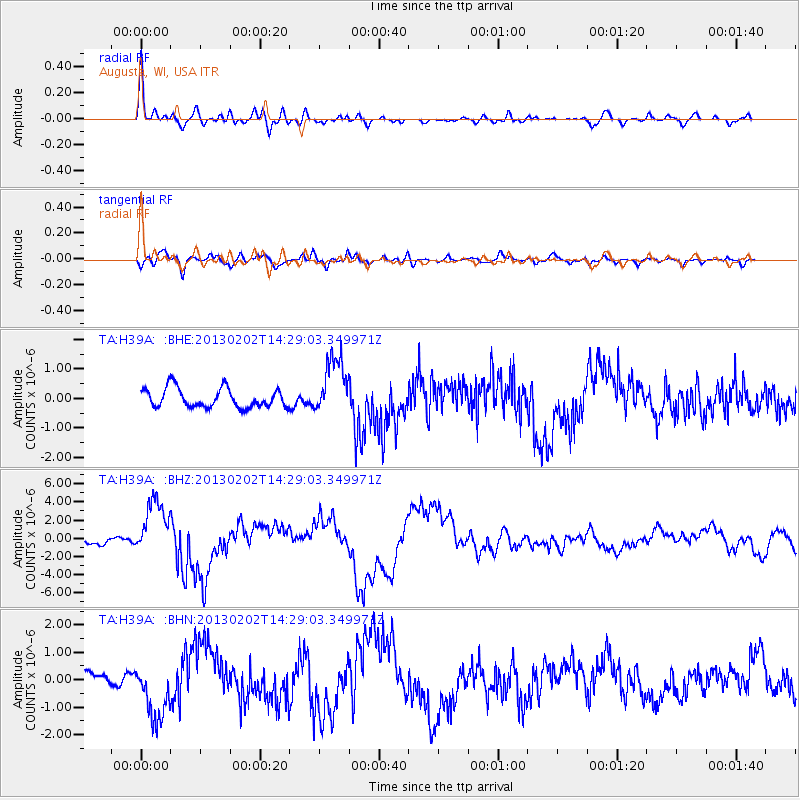
Signal To Noise
| Channel | StoN | STA | LTA |
| TA:H39A: :BHZ:20130202T14:29:03.349971Z | 8.150832 | 3.1251116E-6 | 3.8341014E-7 |
| TA:H39A: :BHN:20130202T14:29:03.349971Z | 3.908797 | 1.0058304E-6 | 2.5732479E-7 |
| TA:H39A: :BHE:20130202T14:29:03.349971Z | 3.0690904 | 9.89441E-7 | 3.22389E-7 |
| Arrivals |
| Ps | 2.0 SECOND |
| PpPs | 5.3 SECOND |
| PsPs/PpSs | 7.2 SECOND |


