You are here: Home > Network List > TA - USArray Transportable Network (new EarthScope stations) Stations List
> Station G40A Rib Lake, WI, USA > Earthquake Result Viewer
G40A Rib Lake, WI, USA - Earthquake Result Viewer
| Earthquake location: |
Hokkaido, Japan Region |
| Earthquake latitude/longitude: |
42.8/143.1 |
| Earthquake time(UTC): |
2013/02/02 (033) 14:17:35 GMT |
| Earthquake Depth: |
107 km |
| Earthquake Magnitude: |
6.4 MB, 6.9 MW, 6.9 MW |
| Earthquake Catalog/Contributor: |
WHDF/NEIC |
|
| Network: |
TA USArray Transportable Network (new EarthScope stations) |
| Station: |
G40A Rib Lake, WI, USA |
| Lat/Lon: |
45.27 N/90.20 W |
| Elevation: |
472 m |
|
| Distance: |
80.3 deg |
| Az: |
35.052 deg |
| Baz: |
323.211 deg |
| Ray Param: |
0.048123013 |
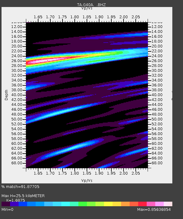
| Estimated Moho Depth: |
25.5 km |
| Estimated Crust Vp/Vs: |
1.69 |
| Assumed Crust Vp: |
6.571 km/s |
| Estimated Crust Vs: |
3.894 km/s |
| Estimated Crust Poisson's Ratio: |
0.23 |
|
| Radial Match: |
91.87705 % |
| Radial Bump: |
400 |
| Transverse Match: |
66.67985 % |
| Transverse Bump: |
400 |
| SOD ConfigId: |
494114 |
| Insert Time: |
2013-04-27 06:38:08.588 +0000 |
| GWidth: |
2.5 |
| Max Bumps: |
400 |
| Tol: |
0.001 |
|

Signal To Noise
| Channel | StoN | STA | LTA |
| TA:G40A: :BHZ:20130202T14:29:03.325007Z | 6.2926726 | 3.1147852E-6 | 4.9498607E-7 |
| TA:G40A: :BHN:20130202T14:29:03.325007Z | 3.19297 | 1.0687543E-6 | 3.3472105E-7 |
| TA:G40A: :BHE:20130202T14:29:03.325007Z | 3.5491128 | 1.0727134E-6 | 3.022483E-7 |
| Arrivals |
| Ps | 2.8 SECOND |
| PpPs | 10 SECOND |
| PsPs/PpSs | 13 SECOND |


