You are here: Home > Network List > TA - USArray Transportable Network (new EarthScope stations) Stations List
> Station F40A Park Falls, WI, USA > Earthquake Result Viewer
F40A Park Falls, WI, USA - Earthquake Result Viewer

| Earthquake location: |
Hokkaido, Japan Region |
| Earthquake latitude/longitude: |
42.8/143.1 |
| Earthquake time(UTC): |
2013/02/02 (033) 14:17:35 GMT |
| Earthquake Depth: |
107 km |
| Earthquake Magnitude: |
6.4 MB, 6.9 MW, 6.9 MW |
| Earthquake Catalog/Contributor: |
WHDF/NEIC |
|
| Network: |
TA USArray Transportable Network (new EarthScope stations) |
| Station: |
F40A Park Falls, WI, USA |
| Lat/Lon: |
45.92 N/90.12 W |
| Elevation: |
486 m |
|
| Distance: |
79.8 deg |
| Az: |
34.611 deg |
| Baz: |
323.191 deg |
| Ray Param: |
0.04845366 |
| Estimated Moho Depth: |
42.75 km |
| Estimated Crust Vp/Vs: |
1.70 |
| Assumed Crust Vp: |
6.571 km/s |
| Estimated Crust Vs: |
3.876 km/s |
| Estimated Crust Poisson's Ratio: |
0.23 |
|
| Radial Match: |
92.30224 % |
| Radial Bump: |
400 |
| Transverse Match: |
76.49591 % |
| Transverse Bump: |
400 |
| SOD ConfigId: |
494114 |
| Insert Time: |
2013-04-27 06:38:33.206 +0000 |
| GWidth: |
2.5 |
| Max Bumps: |
400 |
| Tol: |
0.001 |
|
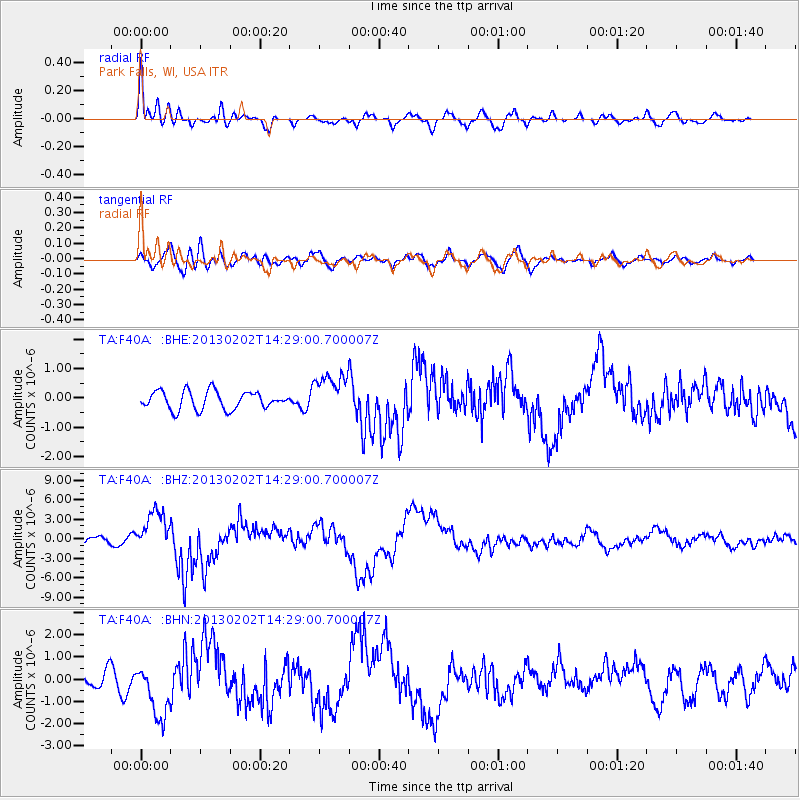
Signal To Noise
| Channel | StoN | STA | LTA |
| TA:F40A: :BHZ:20130202T14:29:00.700007Z | 8.676058 | 3.151164E-6 | 3.6320228E-7 |
| TA:F40A: :BHN:20130202T14:29:00.700007Z | 4.468841 | 1.2087058E-6 | 2.7047412E-7 |
| TA:F40A: :BHE:20130202T14:29:00.700007Z | 2.3045485 | 7.0482304E-7 | 3.0583996E-7 |
| Arrivals |
| Ps | 4.7 SECOND |
| PpPs | 17 SECOND |
| PsPs/PpSs | 22 SECOND |


