You are here: Home > Network List > TA - USArray Transportable Network (new EarthScope stations) Stations List
> Station E42A Champion, MI, USA > Earthquake Result Viewer
E42A Champion, MI, USA - Earthquake Result Viewer
| Earthquake location: |
Hokkaido, Japan Region |
| Earthquake latitude/longitude: |
42.8/143.1 |
| Earthquake time(UTC): |
2013/02/02 (033) 14:17:35 GMT |
| Earthquake Depth: |
107 km |
| Earthquake Magnitude: |
6.4 MB, 6.9 MW, 6.9 MW |
| Earthquake Catalog/Contributor: |
WHDF/NEIC |
|
| Network: |
TA USArray Transportable Network (new EarthScope stations) |
| Station: |
E42A Champion, MI, USA |
| Lat/Lon: |
46.43 N/87.91 W |
| Elevation: |
475 m |
|
| Distance: |
80.3 deg |
| Az: |
33.048 deg |
| Baz: |
324.509 deg |
| Ray Param: |
0.048120078 |
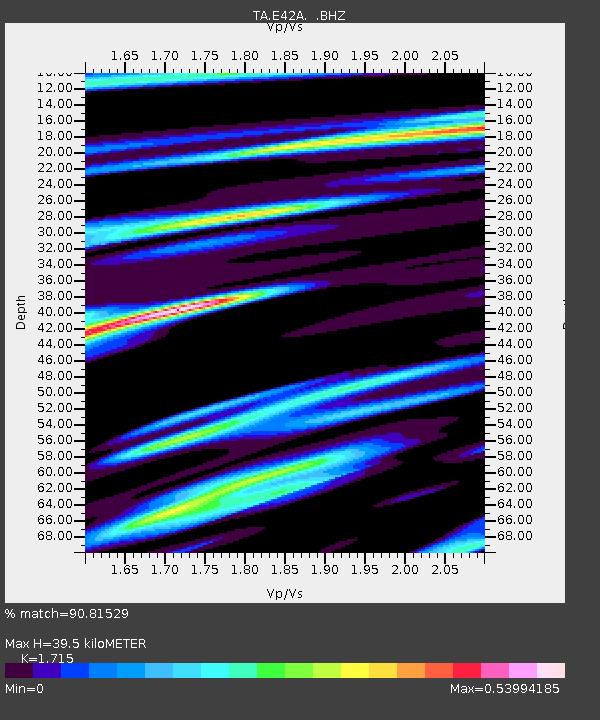
| Estimated Moho Depth: |
39.5 km |
| Estimated Crust Vp/Vs: |
1.72 |
| Assumed Crust Vp: |
6.472 km/s |
| Estimated Crust Vs: |
3.774 km/s |
| Estimated Crust Poisson's Ratio: |
0.24 |
|
| Radial Match: |
90.81529 % |
| Radial Bump: |
392 |
| Transverse Match: |
73.10715 % |
| Transverse Bump: |
400 |
| SOD ConfigId: |
494114 |
| Insert Time: |
2013-04-27 06:39:03.834 +0000 |
| GWidth: |
2.5 |
| Max Bumps: |
400 |
| Tol: |
0.001 |
|

Signal To Noise
| Channel | StoN | STA | LTA |
| TA:E42A: :BHZ:20130202T14:29:03.325007Z | 9.715529 | 3.7714972E-6 | 3.8819263E-7 |
| TA:E42A: :BHN:20130202T14:29:03.325007Z | 4.3637395 | 1.5188069E-6 | 3.480517E-7 |
| TA:E42A: :BHE:20130202T14:29:03.325007Z | 3.699923 | 9.4176363E-7 | 2.54536E-7 |
| Arrivals |
| Ps | 4.5 SECOND |
| PpPs | 16 SECOND |
| PsPs/PpSs | 21 SECOND |


