You are here: Home > Network List > TA - USArray Transportable Network (new EarthScope stations) Stations List
> Station I43A Langenfeld Brothers Farm, Elkhart Lake, WI, USA > Earthquake Result Viewer
I43A Langenfeld Brothers Farm, Elkhart Lake, WI, USA - Earthquake Result Viewer
| Earthquake location: |
Hokkaido, Japan Region |
| Earthquake latitude/longitude: |
42.8/143.1 |
| Earthquake time(UTC): |
2013/02/02 (033) 14:17:35 GMT |
| Earthquake Depth: |
107 km |
| Earthquake Magnitude: |
6.4 MB, 6.9 MW, 6.9 MW |
| Earthquake Catalog/Contributor: |
WHDF/NEIC |
|
| Network: |
TA USArray Transportable Network (new EarthScope stations) |
| Station: |
I43A Langenfeld Brothers Farm, Elkhart Lake, WI, USA |
| Lat/Lon: |
43.88 N/88.15 W |
| Elevation: |
299 m |
|
| Distance: |
82.3 deg |
| Az: |
34.677 deg |
| Baz: |
324.591 deg |
| Ray Param: |
0.046750244 |
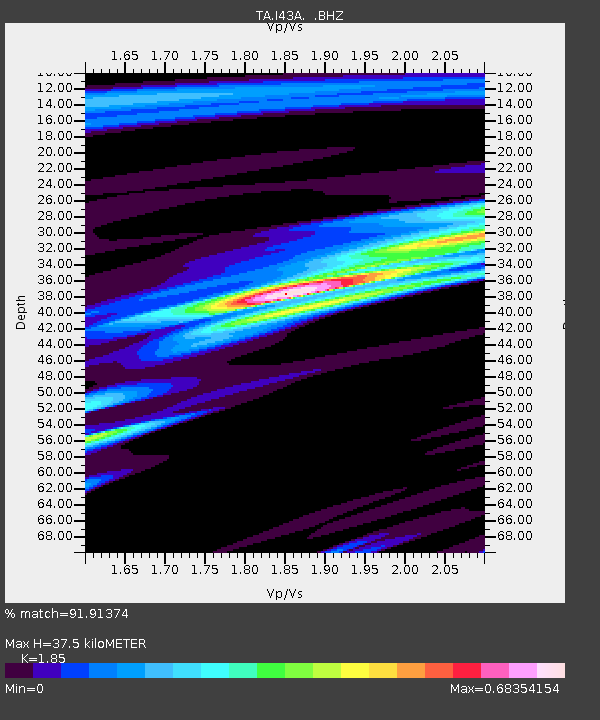
| Estimated Moho Depth: |
37.5 km |
| Estimated Crust Vp/Vs: |
1.85 |
| Assumed Crust Vp: |
6.571 km/s |
| Estimated Crust Vs: |
3.552 km/s |
| Estimated Crust Poisson's Ratio: |
0.29 |
|
| Radial Match: |
91.91374 % |
| Radial Bump: |
400 |
| Transverse Match: |
63.535496 % |
| Transverse Bump: |
400 |
| SOD ConfigId: |
494114 |
| Insert Time: |
2013-04-27 06:40:27.181 +0000 |
| GWidth: |
2.5 |
| Max Bumps: |
400 |
| Tol: |
0.001 |
|

Signal To Noise
| Channel | StoN | STA | LTA |
| TA:I43A: :BHZ:20130202T14:29:13.749995Z | 8.239677 | 3.3329716E-6 | 4.0450269E-7 |
| TA:I43A: :BHN:20130202T14:29:13.749995Z | 4.0528665 | 1.0623344E-6 | 2.6211927E-7 |
| TA:I43A: :BHE:20130202T14:29:13.749995Z | 1.5842153 | 5.9707935E-7 | 3.768928E-7 |
| Arrivals |
| Ps | 5.0 SECOND |
| PpPs | 16 SECOND |
| PsPs/PpSs | 21 SECOND |


