You are here: Home > Network List > TA - USArray Transportable Network (new EarthScope stations) Stations List
> Station J42A Columbus, WI, USA > Earthquake Result Viewer
J42A Columbus, WI, USA - Earthquake Result Viewer
| Earthquake location: |
Hokkaido, Japan Region |
| Earthquake latitude/longitude: |
42.8/143.1 |
| Earthquake time(UTC): |
2013/02/02 (033) 14:17:35 GMT |
| Earthquake Depth: |
107 km |
| Earthquake Magnitude: |
6.4 MB, 6.9 MW, 6.9 MW |
| Earthquake Catalog/Contributor: |
WHDF/NEIC |
|
| Network: |
TA USArray Transportable Network (new EarthScope stations) |
| Station: |
J42A Columbus, WI, USA |
| Lat/Lon: |
43.32 N/89.12 W |
| Elevation: |
313 m |
|
| Distance: |
82.3 deg |
| Az: |
35.592 deg |
| Baz: |
324.042 deg |
| Ray Param: |
0.046718594 |
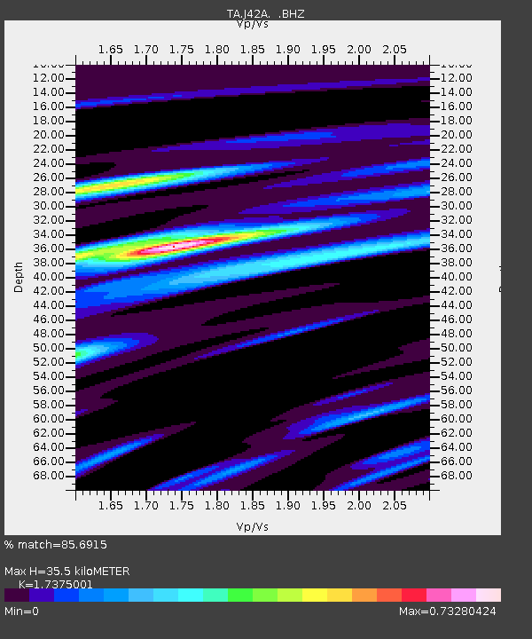
| Estimated Moho Depth: |
35.5 km |
| Estimated Crust Vp/Vs: |
1.74 |
| Assumed Crust Vp: |
6.571 km/s |
| Estimated Crust Vs: |
3.782 km/s |
| Estimated Crust Poisson's Ratio: |
0.25 |
|
| Radial Match: |
85.6915 % |
| Radial Bump: |
400 |
| Transverse Match: |
50.89589 % |
| Transverse Bump: |
400 |
| SOD ConfigId: |
494114 |
| Insert Time: |
2013-04-27 06:40:55.940 +0000 |
| GWidth: |
2.5 |
| Max Bumps: |
400 |
| Tol: |
0.001 |
|
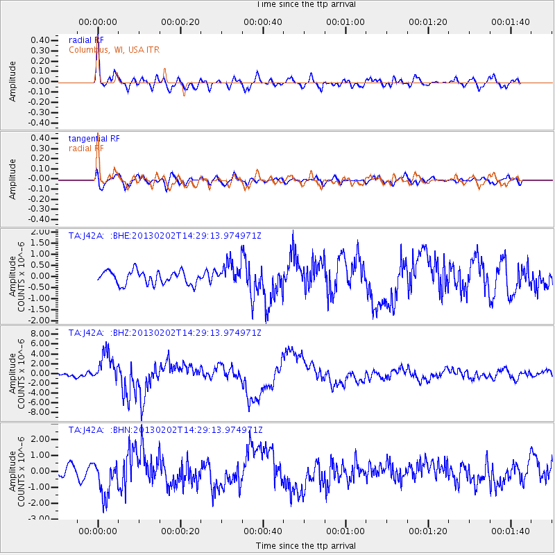
Signal To Noise
| Channel | StoN | STA | LTA |
| TA:J42A: :BHZ:20130202T14:29:13.974971Z | 5.9359384 | 3.1517998E-6 | 5.309691E-7 |
| TA:J42A: :BHN:20130202T14:29:13.974971Z | 1.9696957 | 1.1183648E-6 | 5.6778555E-7 |
| TA:J42A: :BHE:20130202T14:29:13.974971Z | 1.81277 | 5.3418995E-7 | 2.946816E-7 |
| Arrivals |
| Ps | 4.1 SECOND |
| PpPs | 14 SECOND |
| PsPs/PpSs | 18 SECOND |


