You are here: Home > Network List > TA - USArray Transportable Network (new EarthScope stations) Stations List
> Station K43A Burlington, WI, USA > Earthquake Result Viewer
K43A Burlington, WI, USA - Earthquake Result Viewer
| Earthquake location: |
Hokkaido, Japan Region |
| Earthquake latitude/longitude: |
42.8/143.1 |
| Earthquake time(UTC): |
2013/02/02 (033) 14:17:35 GMT |
| Earthquake Depth: |
107 km |
| Earthquake Magnitude: |
6.4 MB, 6.9 MW, 6.9 MW |
| Earthquake Catalog/Contributor: |
WHDF/NEIC |
|
| Network: |
TA USArray Transportable Network (new EarthScope stations) |
| Station: |
K43A Burlington, WI, USA |
| Lat/Lon: |
42.70 N/88.33 W |
| Elevation: |
264 m |
|
| Distance: |
83.2 deg |
| Az: |
35.477 deg |
| Baz: |
324.566 deg |
| Ray Param: |
0.046135094 |
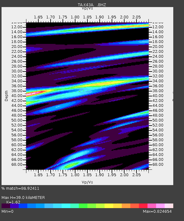
| Estimated Moho Depth: |
39.0 km |
| Estimated Crust Vp/Vs: |
1.62 |
| Assumed Crust Vp: |
6.571 km/s |
| Estimated Crust Vs: |
4.056 km/s |
| Estimated Crust Poisson's Ratio: |
0.19 |
|
| Radial Match: |
86.92411 % |
| Radial Bump: |
400 |
| Transverse Match: |
56.975132 % |
| Transverse Bump: |
400 |
| SOD ConfigId: |
494114 |
| Insert Time: |
2013-04-27 06:41:07.589 +0000 |
| GWidth: |
2.5 |
| Max Bumps: |
400 |
| Tol: |
0.001 |
|
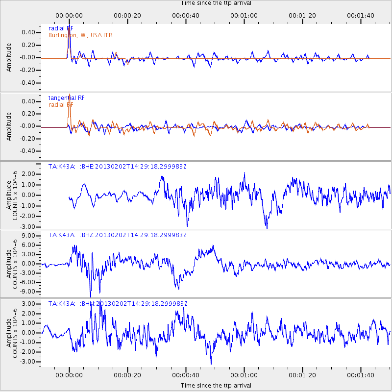
Signal To Noise
| Channel | StoN | STA | LTA |
| TA:K43A: :BHZ:20130202T14:29:18.299983Z | 5.8566213 | 3.1538543E-6 | 5.3851085E-7 |
| TA:K43A: :BHN:20130202T14:29:18.299983Z | 1.8769089 | 9.988601E-7 | 5.321836E-7 |
| TA:K43A: :BHE:20130202T14:29:18.299983Z | 2.1133828 | 9.433877E-7 | 4.4638753E-7 |
| Arrivals |
| Ps | 3.8 SECOND |
| PpPs | 15 SECOND |
| PsPs/PpSs | 19 SECOND |


