You are here: Home > Network List > II - Global Seismograph Network (GSN - IRIS/IDA) Stations List
> Station TAU Hobart, Tasmania, Australia > Earthquake Result Viewer
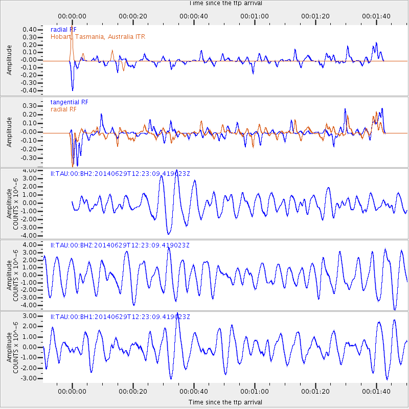
TAU Hobart, Tasmania, Australia - Earthquake Result Viewer
*The percent match for this event was below the threshold and hence no stack was calculated.
| Earthquake location: |
South Sandwich Islands Region |
| Earthquake latitude/longitude: |
-55.3/-28.2 |
| Earthquake time(UTC): |
2014/06/29 (180) 12:11:22 GMT |
| Earthquake Depth: |
26 km |
| Earthquake Magnitude: |
5.4 MW |
| Earthquake Catalog/Contributor: |
ISC/ISC |
|
| Network: |
II Global Seismograph Network (GSN - IRIS/IDA) |
| Station: |
TAU Hobart, Tasmania, Australia |
| Lat/Lon: |
42.91 S/147.32 E |
| Elevation: |
132 m |
|
| Distance: |
82.1 deg |
| Az: |
176.66 deg |
| Baz: |
182.598 deg |
| Ray Param: |
$rayparam |
*The percent match for this event was below the threshold and hence was not used in the summary stack. |
|
| Radial Match: |
66.53465 % |
| Radial Bump: |
388 |
| Transverse Match: |
65.94327 % |
| Transverse Bump: |
400 |
| SOD ConfigId: |
3390531 |
| Insert Time: |
2019-04-12 14:18:43.583 +0000 |
| GWidth: |
2.5 |
| Max Bumps: |
400 |
| Tol: |
0.001 |
|
Signal To Noise
| Channel | StoN | STA | LTA |
| II:TAU:00:BHZ:20140629T12:23:09.419023Z | 1.2738163 | 1.3397497E-6 | 1.0517606E-6 |
| II:TAU:00:BH1:20140629T12:23:09.419023Z | 0.5945896 | 6.506134E-7 | 1.0942226E-6 |
| II:TAU:00:BH2:20140629T12:23:09.419023Z | 4.5325255 | 2.910726E-6 | 6.4218636E-7 |
| Arrivals |
| Ps | |
| PpPs | |
| PsPs/PpSs | |


