You are here: Home > Network List > TA - USArray Transportable Network (new EarthScope stations) Stations List
> Station Q47A Bedord North Lawrence Stars, Bedford, IN, USA > Earthquake Result Viewer
Q47A Bedord North Lawrence Stars, Bedford, IN, USA - Earthquake Result Viewer
| Earthquake location: |
Hokkaido, Japan Region |
| Earthquake latitude/longitude: |
42.8/143.1 |
| Earthquake time(UTC): |
2013/02/02 (033) 14:17:35 GMT |
| Earthquake Depth: |
107 km |
| Earthquake Magnitude: |
6.4 MB, 6.9 MW, 6.9 MW |
| Earthquake Catalog/Contributor: |
WHDF/NEIC |
|
| Network: |
TA USArray Transportable Network (new EarthScope stations) |
| Station: |
Q47A Bedord North Lawrence Stars, Bedford, IN, USA |
| Lat/Lon: |
38.94 N/86.43 W |
| Elevation: |
230 m |
|
| Distance: |
87.1 deg |
| Az: |
36.439 deg |
| Baz: |
325.889 deg |
| Ray Param: |
0.043347236 |
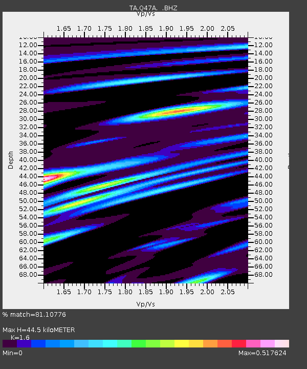
| Estimated Moho Depth: |
44.5 km |
| Estimated Crust Vp/Vs: |
1.60 |
| Assumed Crust Vp: |
6.444 km/s |
| Estimated Crust Vs: |
4.027 km/s |
| Estimated Crust Poisson's Ratio: |
0.18 |
|
| Radial Match: |
81.10776 % |
| Radial Bump: |
400 |
| Transverse Match: |
65.09221 % |
| Transverse Bump: |
400 |
| SOD ConfigId: |
494114 |
| Insert Time: |
2013-04-27 06:42:06.603 +0000 |
| GWidth: |
2.5 |
| Max Bumps: |
400 |
| Tol: |
0.001 |
|

Signal To Noise
| Channel | StoN | STA | LTA |
| TA:Q47A: :BHZ:20130202T14:29:37.724971Z | 6.9490986 | 2.816866E-6 | 4.05357E-7 |
| TA:Q47A: :BHN:20130202T14:29:37.724971Z | 2.0196738 | 6.990937E-7 | 3.461419E-7 |
| TA:Q47A: :BHE:20130202T14:29:37.724971Z | 4.0584736 | 8.115078E-7 | 1.9995393E-7 |
| Arrivals |
| Ps | 4.2 SECOND |
| PpPs | 18 SECOND |
| PsPs/PpSs | 22 SECOND |


