You are here: Home > Network List > TA - USArray Transportable Network (new EarthScope stations) Stations List
> Station Q45A Warren Harvey, Newton, IL, USA > Earthquake Result Viewer
Q45A Warren Harvey, Newton, IL, USA - Earthquake Result Viewer
| Earthquake location: |
Hokkaido, Japan Region |
| Earthquake latitude/longitude: |
42.8/143.1 |
| Earthquake time(UTC): |
2013/02/02 (033) 14:17:35 GMT |
| Earthquake Depth: |
107 km |
| Earthquake Magnitude: |
6.4 MB, 6.9 MW, 6.9 MW |
| Earthquake Catalog/Contributor: |
WHDF/NEIC |
|
| Network: |
TA USArray Transportable Network (new EarthScope stations) |
| Station: |
Q45A Warren Harvey, Newton, IL, USA |
| Lat/Lon: |
38.89 N/88.16 W |
| Elevation: |
162 m |
|
| Distance: |
86.4 deg |
| Az: |
37.575 deg |
| Baz: |
324.871 deg |
| Ray Param: |
0.043877073 |
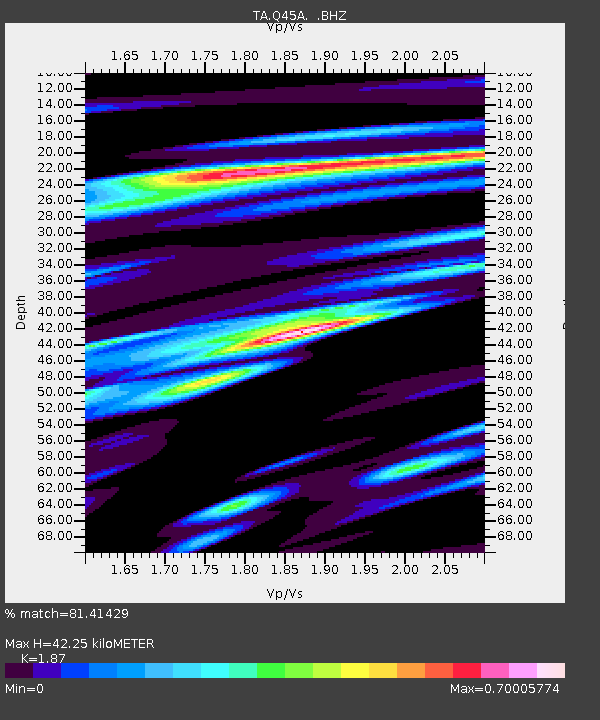
| Estimated Moho Depth: |
42.25 km |
| Estimated Crust Vp/Vs: |
1.87 |
| Assumed Crust Vp: |
6.444 km/s |
| Estimated Crust Vs: |
3.446 km/s |
| Estimated Crust Poisson's Ratio: |
0.30 |
|
| Radial Match: |
81.41429 % |
| Radial Bump: |
400 |
| Transverse Match: |
69.656845 % |
| Transverse Bump: |
400 |
| SOD ConfigId: |
494114 |
| Insert Time: |
2013-04-27 06:42:42.474 +0000 |
| GWidth: |
2.5 |
| Max Bumps: |
400 |
| Tol: |
0.001 |
|

Signal To Noise
| Channel | StoN | STA | LTA |
| TA:Q45A: :BHZ:20130202T14:29:34.174983Z | 4.300656 | 2.9814994E-6 | 6.932662E-7 |
| TA:Q45A: :BHN:20130202T14:29:34.174983Z | 2.02326 | 1.1424231E-6 | 5.6464467E-7 |
| TA:Q45A: :BHE:20130202T14:29:34.174983Z | 2.0395322 | 7.872354E-7 | 3.8598824E-7 |
| Arrivals |
| Ps | 5.8 SECOND |
| PpPs | 18 SECOND |
| PsPs/PpSs | 24 SECOND |


