You are here: Home > Network List > TA - USArray Transportable Network (new EarthScope stations) Stations List
> Station T47A Sharon Grove, KY, USA > Earthquake Result Viewer
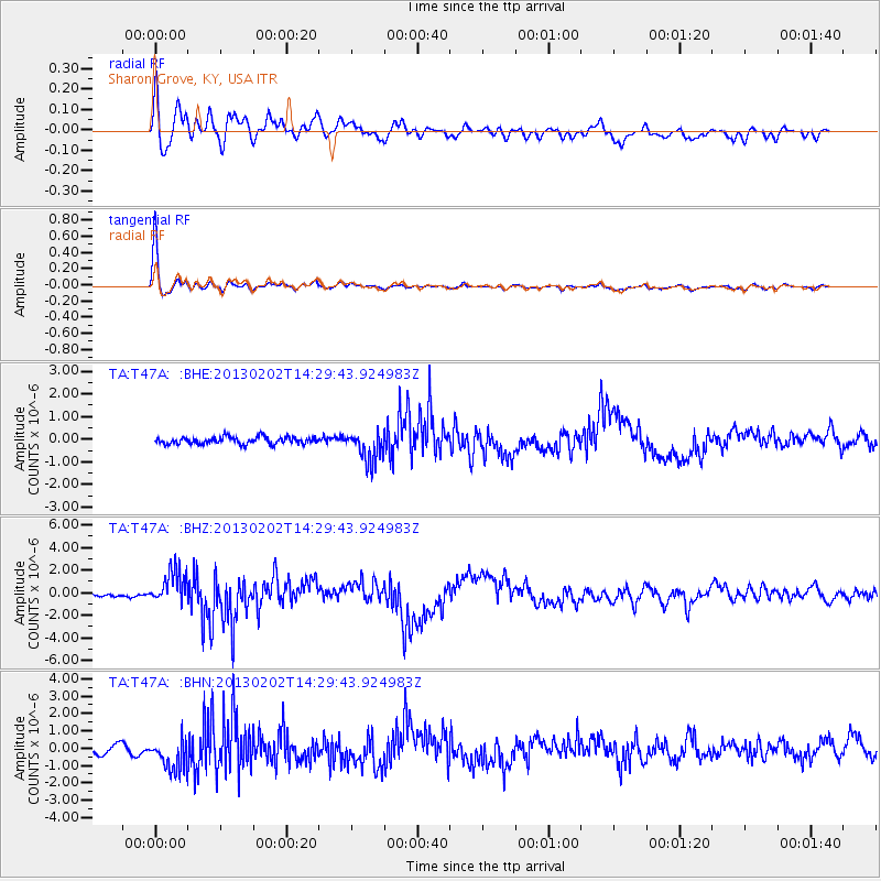
T47A Sharon Grove, KY, USA - Earthquake Result Viewer
*The percent match for this event was below the threshold and hence no stack was calculated.
| Earthquake location: |
Hokkaido, Japan Region |
| Earthquake latitude/longitude: |
42.8/143.1 |
| Earthquake time(UTC): |
2013/02/02 (033) 14:17:35 GMT |
| Earthquake Depth: |
107 km |
| Earthquake Magnitude: |
6.4 MB, 6.9 MW, 6.9 MW |
| Earthquake Catalog/Contributor: |
WHDF/NEIC |
|
| Network: |
TA USArray Transportable Network (new EarthScope stations) |
| Station: |
T47A Sharon Grove, KY, USA |
| Lat/Lon: |
36.99 N/87.11 W |
| Elevation: |
217 m |
|
| Distance: |
88.4 deg |
| Az: |
37.979 deg |
| Baz: |
325.533 deg |
| Ray Param: |
$rayparam |
*The percent match for this event was below the threshold and hence was not used in the summary stack. |
|
| Radial Match: |
62.76303 % |
| Radial Bump: |
400 |
| Transverse Match: |
94.01639 % |
| Transverse Bump: |
264 |
| SOD ConfigId: |
494114 |
| Insert Time: |
2013-04-27 06:42:50.050 +0000 |
| GWidth: |
2.5 |
| Max Bumps: |
400 |
| Tol: |
0.001 |
|
Signal To Noise
| Channel | StoN | STA | LTA |
| TA:T47A: :BHZ:20130202T14:29:43.924983Z | 5.7983003 | 1.4276828E-6 | 2.4622437E-7 |
| TA:T47A: :BHN:20130202T14:29:43.924983Z | 3.8479338 | 1.0047974E-6 | 2.6112647E-7 |
| TA:T47A: :BHE:20130202T14:29:43.924983Z | 4.477368 | 6.911724E-7 | 1.5437024E-7 |
| Arrivals |
| Ps | |
| PpPs | |
| PsPs/PpSs | |


