You are here: Home > Network List > TA - USArray Transportable Network (new EarthScope stations) Stations List
> Station V46A Holladay, TN, USA > Earthquake Result Viewer
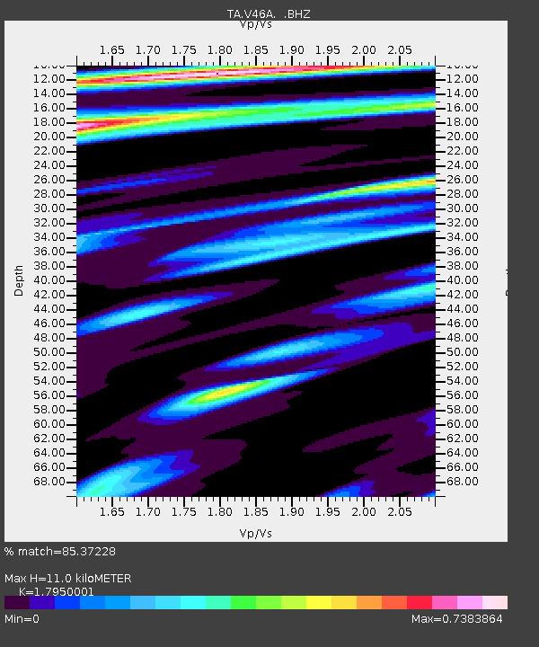
V46A Holladay, TN, USA - Earthquake Result Viewer
| Earthquake location: |
Hokkaido, Japan Region |
| Earthquake latitude/longitude: |
42.8/143.1 |
| Earthquake time(UTC): |
2013/02/02 (033) 14:17:35 GMT |
| Earthquake Depth: |
107 km |
| Earthquake Magnitude: |
6.4 MB, 6.9 MW, 6.9 MW |
| Earthquake Catalog/Contributor: |
WHDF/NEIC |
|
| Network: |
TA USArray Transportable Network (new EarthScope stations) |
| Station: |
V46A Holladay, TN, USA |
| Lat/Lon: |
35.80 N/88.12 W |
| Elevation: |
162 m |
|
| Distance: |
88.9 deg |
| Az: |
39.326 deg |
| Baz: |
324.967 deg |
| Ray Param: |
0.042017188 |
| Estimated Moho Depth: |
11.0 km |
| Estimated Crust Vp/Vs: |
1.80 |
| Assumed Crust Vp: |
6.38 km/s |
| Estimated Crust Vs: |
3.555 km/s |
| Estimated Crust Poisson's Ratio: |
0.27 |
|
| Radial Match: |
85.37228 % |
| Radial Bump: |
400 |
| Transverse Match: |
76.729546 % |
| Transverse Bump: |
400 |
| SOD ConfigId: |
494114 |
| Insert Time: |
2013-04-27 06:44:39.542 +0000 |
| GWidth: |
2.5 |
| Max Bumps: |
400 |
| Tol: |
0.001 |
|

Signal To Noise
| Channel | StoN | STA | LTA |
| TA:V46A: :BHZ:20130202T14:29:46.325007Z | 11.954363 | 2.0107489E-6 | 1.6820209E-7 |
| TA:V46A: :BHN:20130202T14:29:46.325007Z | 2.2801518 | 5.1867625E-7 | 2.2747444E-7 |
| TA:V46A: :BHE:20130202T14:29:46.325007Z | 3.3376312 | 5.920982E-7 | 1.7740074E-7 |
| Arrivals |
| Ps | 1.4 SECOND |
| PpPs | 4.7 SECOND |
| PsPs/PpSs | 6.1 SECOND |


